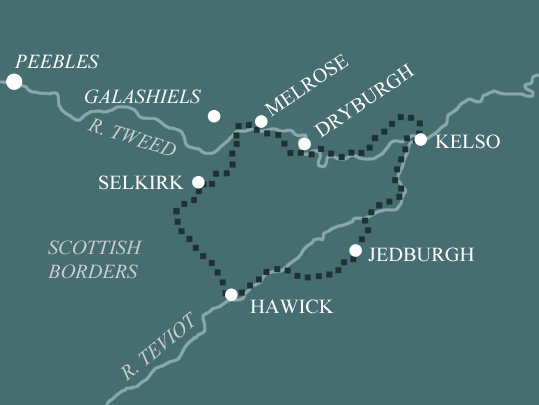
Borders Abbeys Way
Round Trip from Melrose in 4 Days Walking Code: BA5
We offer 4 itineraries on the Borders Abbeys Way. This scenic circuit through the Scottish Borders follows riverbanks, old drove roads, and quiet countryside trails, linking the medieval abbeys of Melrose, Dryburgh, Kelso, and Jedburgh. When choosing, consider how much time you’d like to spend exploring the ruined abbeys and other historical sites along the way.
This 4 day walk is perfectly achievable by strong walkers used to longer days, but it does involve 3 lengthy distances ahead of the final day. It’s perhaps best suited to those who wish to enjoy the stunning Scottish Borders countryside, but are less inclined to spend more time at the abbeys and other historical sites. Alternatively to combine the reward of long days walking and an interest in the local history, simply factor in a rest day.
| Miles | Km | ||
|---|---|---|---|
| Day 1 | Travel to Melrose for your first nights accommodation | ||
| Day 2 | Melrose to Kelso | 18 | 29 |
| Day 3 | Kelso to Denholm | 21 | 34 |
| Day 4 | Denholm to Selkirk | 19 | 31 |
| Day 5 | Selkirk to Melrose | 10 | 16 |
| Day 6 | Depart from Melrose after breakfast |
Melrose to Dryburgh
The Borders Abbeys Way leaves Melrose and heads first to the neighbouring village of Newstead. Dating back to at least AD650, Newstead claims to be the oldest continuously inhabited village in Scotland. In medieval times it was home to stonemasons working on Melrose Abbey.
Breaking away from Newstead the Way then heads in the direction of the Eildon Hills. The highest of the three tops was used by the Romans as a signal station. Earlier still it had been an Iron Age fort belonging to the Votadini tribe.
Beneath the Eildon’s stands the Rhymer’s Stone on the site of the fabled Eildon Tree. It was here that Thomas the Rhymer took a nap and vanished off to the land of the elves. Careful where you rest!
Just beyond here there is an option to follow a waymarked path and scale the steep sided Eildon Hills. It’s a detour requiring a bit of an effort however the far reaching views are a fantastic reward. A more leisurely alternative would be to factor in a rest day at Melrose where you can further explore the Abbey and visit the Roman Museum while spending a half day walking the Eildon Hills on the route of St Cuthbert’s Way.
Sticking to the Way, the pretty hamlet of Eildon is passed as you head to Newtown St Boswells with its impressive wooded glen, identified by Scottish Natural Heritage as an ancient semi-natural woodland site. St Cuthbert’s Way meets the Abbeys Way in Newtown, having crossed the Eildon Hills to Bowden. The two routes share the trail through the glen until the banks of the River Tweed when St Cuthbert’s remains south of the river and the Abbeys Way crosses the suspension bridge arriving at Dryburgh.
Built in 1817, the first suspension bridge replaced a ferry service. It was the first suspension bridge to be built in Scotland, but it was short lived, destroyed by a gale the following year. A subsequent bridge collapsed. Today’s bridge, utilising cables as opposed to chains, was constructed in 1872.
Dryburgh to Kelso
Immediately over the Dryburgh Suspension Bridge on a natural mound known as Bass Hill, stands the neoclassical Temple of the Muses, erected in 1818 by the 11th Earl of Buchan in tribute to poet and playwright James Thomson, who penned the lyrics to Rule Britannia. Less than a mile to the north stands a thirty foot statue of William Wallace, erected in 1814, again by the 11th Earl of Buchan.
The Way continues past Dryburgh Abbey and follows woodland and field track along the River Tweed before breaking off to the hamlet of Clintmains, re-joining again beyond Magdalene Hall. The Tweed is one of the most prestigious salmon fishing rivers in Scotland. In medieval times, fishing rights were controlled by the abbey monks. Today you can be expected to pay up to £4000 a week to fish some stretches of the river.
The Way once again leaves the Tweed at Dalcove and travels through farmland passing estate cottages following grassy lanes, minor roads and field margins all the way to Kelso. This is classic Scottish Borders countryside and it’s a delight to walk through.
Kelso to Jedburgh
From the Market Square the Way heads along Bridge Street to Kelso Abbey before crossing the River Tweed via Kelso Bridge. As at Dryburgh, the original bridge, built in 1754 replaced a ferry service, which could be dangerous when the river was high. Following the collapse of the original bridge the current bridge was built in 1803.
Shortly after crossing Kelso Bridge the Tweed forks with the River Teviot and it’s the Teviot the Abbeys Way follows. The Way passes beneath the ruins of Roxburgh Castle, superbly sited on the promontory between the Tweed and the Teviot rivers. The Castle was built in 1125 by King David I of Scotland. Parts of northern England were under Scottish control at the time and the construction of Roxburgh was undoubtedly an attempt by the king to strengthen his authority in the region. The castle changed hands several times during the Scottish Wars of Independence and was eventually destroyed by Scottish forces in 1460 when they captured it from the English.
The Way continues along the banks of the Teviot passing beneath Roxburgh Viaduct, beyond where Sunlaws Caves can be seen. It is said that in 1745 Bonnie Prince Charlie sheltered his horses in the caves during his march from Jedburgh to Kelso.
Leaving the river for a time the way follows disused railway to the hamlet of Nisbet, a designated Conservation Area, its appearance having changed little since the 19th century.
Before entering Jedburgh the Way briefly meets St Cuthbert’s Way on the Roman road, Dere Street which ran from York to Edinburgh and possibly beyond to Perth. The road’s Roman name is lost in time. Dere Street, the modern English name has its origins in the post-Roman Anglo Saxon kingdom of Deira.
Jedburgh to Hawick
The Way climbs out of Jedburgh through farmland to the flanks of Black Law. On a clear day it’s worth the effort to make the short diversion to the summit (338m) to enjoy the panoramic views. Although waymarked, the trail alongside Black Law can be indistinct in places and concentration is required in poor weather. Ensure you refer to your map at regular intervals.
The Way descends adjacent to Blacklaw Strip, a wooded gulley and makes its way to the hamlet of Bedrule before crossing the Rule Water on its way to the quaint village of Denholm, notable for its Gothic styled spire in the centre of the village green. The commemorative monument is in honour of Denholm born Dr John Leyden an orientalist scholar instrumental in the founding of Singapore.
Once through Denholm a mix of riverside path, minor road and woodland follow the Teviot to Knowtownhead. Here the Way splits for a time and you can choose between minor road or riverside path, probably influenced by how wet the ground is, before the Way merges again at Hornshole Bridge on the outskirts of Hawick, the largest of the towns visited on the Abbeys Way, second largest in the Borders behind Galashiels.
Hawick to Melrose
The Way climbs out of Hawick on minor roads to Tandlaw Moss and crosses Boonraw Burn entering undulating farmland and makes its way to Ashkirk Forest, a large conifer plantation. Here the route shares the woodland with the Cross Border Drove Road. Emerging from the woods the two paths split for a time as the Abbeys Way follows hillside and further plantation along a stretch known as the Thief’s Road, so called on account of the notorious Moss Troopers, who like the earlier Border Rievers, were a lawless group who prayed on civilians.
The Way once again meets the Drove Road and heads into another plantation at Woll Rigg to meet the Bishop’s Stone, the highest point on the Borders Abbeys Way at 337m. Although you will have bettered this by a metre if you summited Black Law on leaving Jedburgh! The Bishop’s Stone, built into the base of a wall, is thought to have marked a boundary of the lands belonging to the Bishop of Glasgow at the beginning of the 12th century.
Beyond the stone the Way heads deeper into Hartwoodmyres Forest before dropping downhill onto farm tracks to meet the minor road at Middlestead Farm saying farewell the Cross border Drove Road as it heads to Bowhill and the Southern Uplands. The Abbeys Way follows the minor road for a short time before traversing fields to Haining Loch and into the town of Selkirk.
Leaving Selkirk the Way heads over Selkirk Hill, a haven for wildflowers and wildlife and utilises an old drove road as it makes it way down to Cauldshiels Loch and through the Shillinglaw and Broomylaw plantations emerging by Abbottsford House, the magnificent former residence of Sir Walter Scott.
From Abbottsford the Abbeys Way hugs the banks of the River Tweed as it winds its way past Tweedbank and onto Melrose sharing a final section of trail with the Southern Upland Way until it heads over the Chain Bridge to Gattonside and the Abbeys Way turns towards town and Melrose Abbey.
Moderate
When walked at a comfortable pace The Borders Abbeys Way can be completed by people with limited walking experience who have a reasonable level of fitness. However, the shorter itineraries involve some lengthy days which require careful consideration. The open hillside and higher moorland tracks between Jedburgh and Denholm will be a little more challenging than the riverside paths and farm tracks more common on the route.
Terrain: Varied, comprising riverside paths, farm tracks, old railway and sections of minor road as well as forest path, open hillside and higher moorland tracks.
What’s it like underfoot? On the whole the paths are well defined and maintained, however at times riverside paths, open hillside and higher moorland tracks can be muddy or slippy in places.
How Much Up & Down? Lowland Scotland can be hilly, but unlike the Highlands of Scotland or the Lake District, it is not mountainous. An overall height gain of around 4265 feet (1,300m) with the highest point being 1,113 feet (338 m)
Signposting: Generally good with a W-shaped Borders Abbeys Way logo. However the path can be indistinct in places so pay attention to waymarkers and refer to your map at regular intervals, especially on the higher, hillier sections between Jedburgh and Denholm.
Navigation: The Borders Abbeys Way is shown on the Ordnance Survey map supplied. By following the directions in your guidebook and confirming your position on the map, navigation should be straightforward.
Weather: Pack your floppy hat and sun cream. You may be lucky enough to encounter warm, dry weather over the whole route and enjoy dry paths and tremendous views, but you must be prepared because the weather can change quickly. Good clothing including comfortable footwear and reliable waterproofs are essential.
|
All Holidays
|
|
| Accommodation | Overnight Bed and Breakfast accommodation in selected hotels, farmhouses, village inns, guest houses and family B&Bs. Cooked or Continental breakfast. |
| Guidebook | A detailed guidebook with route information, maps, photos and background information. |
| Information of Services Along the Route | A comprehensive Service Info sheet, including services such as cash points, banks, post offices, village shops, inns, cafes and taxis. |
| Maps | Four (1:25,000) Ordnance Survey Explorer maps, including mobile download, covering the entire route. |
| Personal Itinerary | A personal itinerary setting out each overnight stop, including large scale maps of each accommodation, to ensure you find it easily. |
| Emergency Telephone Support | If you get in to difficulties during your holiday, we are always available to help, even out of office hours. |
|
Options
|
|
| Luggage Transport | We will transfer your luggage between each overnight stop – if you leave your luggage at the accommodation when you set off in the morning, it will be moved on to your next B&B. You only need to carry a small day sack with the clothes and provisions you require during the day’s walk. |
| Packed Lunches |
Provided for each day’s walking and recommended on this holiday as there will not always be a handy shop or cafe on the route. |
| Off Road Parking | If you are travelling by car we can usually arrange off road parking for the duration of your trip. (There may be a small charge for this). |
| Arrangement of return transport | We can also arrange your transfer back to your car, (or advise you when public transport is a better option)! |
|
What’s not Included
|
|
| Evening Meals | Your evening meal isn’t included in the package, but we include full details and recommendations for each evening meal in your itinerary. You will normally be within walking distance of a pub and/or restaurant, or where there is good food available at the accommodation, we’ll book that for you. Allow about £30.00 per night. |
| Transport to the Start & Away from the Finish | Have a look at the ‘Travel Info’ tab above for suggestions. If you’re still struggling, get in touch and we’ll help you sort it out. |
| Travel Insurance | Even if you are based in the UK travel insurance is worth having. |
Good accommodation and friendly hosts are an essential part of any holiday. We understand this and go out of our way to find the best. We put a great deal of effort into hand picking our accommodation and matching it to individual customer requirements. As well as visiting the accommodation ourselves, we ask all our customers to complete a short evaluation on each night’s accommodation, which then gives us an insight into the day-to-day operation and lets us spot any potential issues before they become a problem.
We use a variety of accommodation. Over the course of your trip you might stay in a village inn, a bed and breakfast in a converted barn, a Victorian guest house, or on a working farm. In selecting the accommodation we look for helpful, friendly hosts with good quality, characterful accommodation close to the trail. Occasionally we may use a chain hotel.
We always try to arrange en suite accommodation, i.e. rooms with their own bathrooms for each night of your stay. However, in some of the more remote locations accommodation is limited and occasionally we may have to book rooms with shared bathrooms for one or two nights of your holiday, (especially if the booking is made at short notice), but we will always let you know if this is likely to be the case.
We are happy to book single rooms on our holidays but cannot normally book more than two for any one group. Single room bookings include a supplement.
Here are some examples of the accommodation we use on the Borders Abbeys Way:
 The Townhouse Hotel in Melrose offers a charming blend of contemporary style and traditional Scottish hospitality. Run by the Henderson family, this beautifully maintained hotel features elegantly styled interiors and individually furnished bedrooms. Enjoy delicious cuisine and a relaxed ambiance in their welcoming brasserie. Visit their website
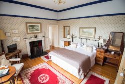 Robin looks forward to greeting guests at the Old Priory in Kelso. Enjoy a little bit of luxury, warmth and the chance to stay in a house dating from 1796. The key to Robin’s hospitality is choice, he offers a wider range of dishes for breakfast than most accommodation providers as well as a magnificent range of teas. Visit their website
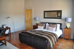 Donna welcomes you to The Bank Guest House in Hawick. This Grade B listed property, a one time Royal Bank of Scotland, was built in 1857, and has been lovingly converted into a commodiously proportioned luxurious home where Victorian Grandeur fuses effortlessly with modern contemporary design. Visit their website
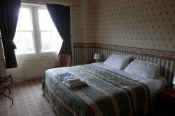 Steve is your host at the family run Glen Hotel situated on the River Ettrick in Selkirk. This picturesque hotel of Victorian roots provides a pleasant and welcoming ambience, making guests feel right at home. A world away from the hustle and bustle of daily life. Visit their website
General travel information for the Borders Abbeys Way will be in your holiday pack.
Detailed instructions on getting to your first night’s accommodation by car, or on foot from the nearest train or bus station, will also be included in the holiday pack on individual accommodation maps.
To view train times please visit trainline where you can also purchase tickets in advance. For information on bus timetables please visit traveline
If you require secure car parking whilst walking this route, please contact us for information.
Getting to Melrose:
By Air: The nearest International Airports to the trail are Edinburgh and Newcastle. If flying via Edinburgh Airport, the Airlink 100 shuttlebus service runs every 10 minutes to Edinburgh Waverley Station from where trains run direct to Tweedbank (1.5 miles from Melrose). If flying into Newcastle Airport, there is a Tyne & Wear Metro station with frequent services to Newcastle Central Station from where trains run direct to Berwick-upon-Tweed and Edinburgh.
By Public Transport: The most convenient railway station for Melrose is Tweedbank (1.5 miles) arriving from Edinburgh Waverley. Alternatively, Berwick-upon-Tweed followed by a 40 miles bus journey to Melrose.
By Road: Melrose is located on the A6091, just off the A7 between Carlisle and Galashiels and the A68 between Otterburn and Edinburgh.
From the M6 (Carlisle): Leave the M6 at junction 44 and follow signs for the A7 (North) Hawick and Galashiels. After passing through Hawick, follow signs for Melrose.
From the A1 (Newcastle): Leave the A1(M) at Junction 77 and follow signs for the A696 Jedburgh. On reaching Otterburn, continue on the A68 and shortly after passing Jedburgh, follow signs for Melrose.
Getting Back:
As this is a circular route you will be walking back to your starting location so you can depart by the same means you arrived.
Melrose
The picturesque town of Melrose is a great place to explore ahead of your Borders Abbeys walk. In addition to the abbey itself there a host of fascinating places to see. The Eildon Hills watch over the town and the triple peaks are visible from much of the Abbeys Way. Why not spend half a day exploring them and look out over the borderlands.
The Romans occupied this area arriving circa AD80, building a prominent fort named Trimontium, ‘Place of the Three Hills’. You can learn all about this and Roman life in Scotland in the Trimontium Museum.
There are two National Trust for Scotland gardens to visit. Priorwood features an apple orchard as well as a dried flower garden while Harmony Gardens is a stunning walled garden looking over to the Eildon hills.
Melrose also boasts a fine selection of independent book, crafts and delicious food shops.
Just a few miles out of town on the banks of the Tweed stands Abbotsford House the former home of novelist, poet, playwright, and historian Sir Walter Scott.
If you’re walking itinerary won’t allow you enough time to do so, then why not use a rest day in Melrose to travel the short distance to Dryburgh and explore the abbey?
Melrose Abbey
Founded in 1136 by monks of the Cistercian Order, Melrose Abbey is among the most beautiful ruined abbeys in the country.
King David I of Scotland’s wish was that the abbey be sited two miles to the east, on the site of an earlier Celtic monastery founded by Saint Aiden in AD635, however the monks persuaded the king to accept the current site claiming it was more suitable for agriculture. Furthermore, the monks preference was on the main route connecting Edinburgh to England, the paved Roman road (Dere Street), perfectly situated to provide accommodation, food and other services to travellers.
Melrose Abbey allegedly contains the heart of Robert the Bruce, King of Scots (1274-1329). It is claimed his heart was buried there in 1330 or 1331. The remainder of Bruce’s body was interred at Dunfermline Abbey. A lead container, conceivably containing the King’s heart, was found buried below the abbey’s chapter house floor in 1996. The container was never opened and was reburied at the abbey on 22 June 1998. King Alexander of Scotland (1198-1249) is also buried at the abbey.
In 1322 the abbey was almost completely destroyed by the army of King Edward II of England (1284-1327). The abbey was attacked again 63 years later by King Richard II of England (1367-1400), resulting in damage so severe, masons laboured for more than a century to restore the abbey.
The abbey was severely damaged during an offensive led by the Earl of Hertford in 1544. It was never rebuilt.
Carved masonry from the abbey is incorporated into buildings and walls around the town.
Dryburgh Abbey
Built in 1150 by canons of the Premonstratensian Order, Dryburgh Abbey sits on the banks of the River Tweed approximately four miles east of Melrose. Historical documents indicate that the abbey was constructed on the remains of an earlier Celtic monastery. The abbey was founded with the agreement of King David I of Scotland by Hugh de Morville, an Anglo-Norman noble and High Lord Constable of Scotland.
In 1316 King Robert the Bruce used Dryburgh Abbey as a base for raids into England. Revenge attacks by the English King Edward II in 1322 resulted in the abbey being looted and severely damaged by fire. Dryburgh along with the other Borders abbeys remained in hands of King Edward until the middle of the 14th century, when the region reverted to Scots control, now ruled by King David II of Scotland (1324-1371). Incensed by his losses, King Edward mounted a vicious campaign of retribution resulting in Edinburgh being sacked and burned. On their return to England through the Borders, Edward’s armies again looted and set fire to Dryburgh Abbey. The abbey was destroyed for a third time in 1443, although this time apparently by accident.
Scottish historical novelist, poet, playwright, and historian, Sir Walter Scott who resided at Abbotsford House near Melrose is buried at the abbey. Field Marshall Sir Douglas Haig, commander of British forces on the Western Front from 1915 until the end of World War I, is also buried within the grounds of the abbey.
Kelso
Standing on the junction of the rivers Tweed and Teviot, Kelso is rich in architectural and historical interest. Its cobbled square, home to a variety of specialist shops, claims to be the largest in Scotland.
Scotland’s largest inhabited house, Floors Castle, overlooks the Tweed and houses exceptional collections of furniture, paintings, porcelain and tapestry.
Why not try your hand at curling or test your balance skating at the Border Ice Rink.
Friday night is folk night in Kelso. You can either sit back or enjoy the music or with great encouragement have a go yourself on the open mic.
The town’s agricultural heritage is celebrated with a variety of events including the Border Union agricultural show, the Scottish Championship dog show, Kelso Races and point-to-point horse racing, as well as the River Tweed Salmon Fishing Museum.
Kelso Abbey
Founded in 1128 by monks of the Tironesian Order, Kelso Abbey is the oldest of the Borders abbeys, and was King David I of Scotland’s base in the Lowlands.
Kelso Abbey was once one of the wealthiest abbeys in Scotland. Its vast estate contained Scotland’s finest agricultural land and lucrative fisheries on the Tweed and Teviot rivers. However, it suffered the same ravages as the other Borders abbeys and was burned and looted on a number of occasions. Today, only the west tower and transept remain.
King James II of Scotland (1430-1460) was killed within sight of Kelso Abbey during a battle securing Scottish repossession of nearby Roxburgh Castle from the English. Following the death of his father, a hasty coronation of the infant successor, King James III of Scotland (1451-1488) took place at the abbey.
Following the Scottish Reformation in 1560, the abbey’s estates were granted to Robert Ker of Cessford, an ancestor of the current Duke of Roxburghe, who resides at Floors Castle on the outskirts of Kelso. Several generations of Duke of Roxburghe and members of their family are buried at Kelso Abbey.
| Prices | CAD ($) |
|---|---|
| Accommodation, map & guidebook only | $1203 |
| with Luggage Transport | $1333 |
| with Packed Lunches | $1291 |
| with Luggage & Lunches | $1414 |
Other Options |
|
| Extra Nights (per night) | $181 |
| Single Supplement (per night) | $124 |
| Solo Luggage Supplement (per day) | $32 |
