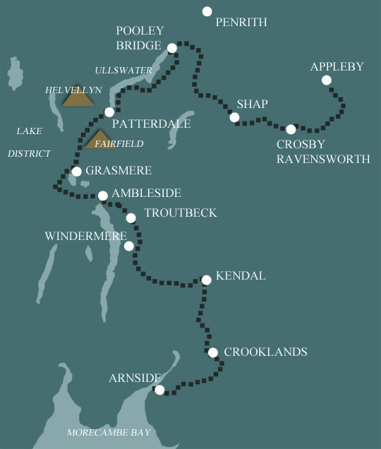
Westmorland Way
Appleby to Arnside in 9 Days Walking Code: WW10
We offer 3 itineraries along the full length of the Westmorland Way. Follow tranquil riverside paths, cross rolling farmland, and wander through picturesque villages. Along the way, take in breathtaking views over Ullswater and Windermere, explore historic landmarks, and enjoy the quiet beauty of this lesser-travelled route.
This is our longest Westmorland Way itinerary covering the 95 miles in 9 days. The longest day is 15 miles from Troutbeck to Kendal and there is a mountainous section between Patterdale and Grasmere, but it is perfectly achievable by all fit walkers. We have split the walk between Kendal and Arnside, where the Lancaster Canal joins us with its interesting towpaths and countryside views.
Please note it may not always be possible to start this itinerary on a Friday or Saturday. If you have flexibility with your dates, please avoid having your first night on a Friday or Saturday. Alternatively, we may be able to amend the itinerary slightly to accommodate.
| Miles | Km | ||
|---|---|---|---|
| Day 1 | Travel to Appleby for your first nights accommodation | ||
| Day 2 | Appleby to Crosby Ravensworth then transfer back to Appleby | 12 | 19 |
| Day 3 | Transfer back to Crosby Ravensworth then walk to Bampton Grange | 10 | 15 |
| Day 4 | Bampton Grange to Pooley Bridge | 10 | 15 |
| Day 5 | Pooley Bridge to Patterdale | 12 | 19 |
| Day 6 | Patterdale to Grasmere | 9 | 14 |
| Day 7 | Grasmere to Troutbeck | 11 | 18 |
| Day 8 | Troutbeck to Kendal | 15 | 24 |
| Day 9 | Kendal to Crooklands | 8 | 12 |
| Day 10 | Crooklands to Arnside | 10 | 16 |
| Day 11 | Depart from Arnside after breakfast |
Appleby to Pooley Bridge
The first day starts under the Pennines and ends on the fringe of Lakeland. Starting along the River Eden, the route leads through fields and quiet lanes linking Great Ormside and Great Asby, two lovely Eden Valley villages in between, the charms of Rutter Force are enjoyed. Carrying on over higher ground you will walk to Crosby Ravensworth, a secluded town. Shap is then reached by way of a stone circle and some typical limestone scenery.
On leaving Shap you will walk past Keld Chapel and Shap Abbey before arriving at the river Lowther. Later, a climb up to the lovely village of Askham will provide you with some wonderful views. The route then drops down to a Norman church at Barton where you will meet the River Eamont. Follow the river to Pooley Bridge which is located at the end of Ullswater, England’s second largest lake.
Pooley Bridge to Grasmere
From Pooley Bridge the walk climbs gently on to the slopes of Barton Fell, where easy routes lead past an impressive stone circle before commencing a classic descent towards Howtown, with tremendous views down to the Lake.
The route then takes in isolated and scattered communities of farmsteads and churches before heading to the lakeshore for a fine walk to Patterdale.
The villages of Patterdale and Grasmere are split by a high mountain range, the longest high level range in Lakeland. The initial miles are through the side valley of Grisedale which penetrates deep into the folds of the Helvellyn range, before a climb to Grisedale Tarn. From here it is a short descent to Grasmere, directly below you, the home of William Wordsworth’s Dove Cottage.
Grasmere to Kendal
Between Grasmere and Troutbeck you will walk through central Lakeland and two popular valleys, finishing in a third. Three separate climbs will be encountered, all on easy paths and enjoying amazing views.
From Elterwater in the beautiful Langdale valley, you will follow the river Brathay into bustling Ambleside. The final stretch encounters Jenkin Crag, which provides glorious views across Windermere (England’s largest lake) to the Langdale Pikes, before dropping down to this evening’s accommodation in Troutbeck.
Troutbeck is famous for its beautiful 17th Century farmhouses with mullioned windows and tall cylindrical chimneys, so characteristic of Westmorland. From Troutbeck, field paths are largely used to approach the attractive fell of School Knot, a major local landmark, before charming undulating paths lead you to Underbarrow, in the Lyth Valley.
A final climb up to Scout Scar with a picturesque walk along the edge is followed by a gradual descent into the medieval market town of Kendal, for your overnight accommodation.
Kendal to Arnside
On leaving Kendal the river Kent will accompany you for several miles, before being replaced with the Lancaster Canal and its towpath with undulating countryside and fine views. Woodland paths take over and after climbing the Fairy Steps you will head down to the Pele Tower at Hazelslack. The final climb is 500 feet to the crest of Arnside Knott which leads to fine views over Morecambe Bay, before descending to the end of the walk, on the Kent estuary in Arnside.
Moderate
With easy-to-follow paths in the main and moderate gradients throughout, the Westmorland Way is accessible to all relatively fit walkers.
Terrain: Rolling hills and moorland, Lakeland fells, then the lowlands of South Cumbria.
What’s it like underfoot? Generally good tracks and paths, but some of the early sections are not as well maintained as other routes. The section through the Lake District is a bit rougher, but there are good paths for the hills.
How much up & down? Rolling countryside for much of the route, with more ascent and descent in the central section through the Lakes. The biggest climb is 450m up to Grisedale Tarn from Patterdale.
Signposting: None
Navigation: Less well defined tracks in the early part, but well defined paths from Pooley Bridge onwards. You might encounter hill fog going over Grisedale, but the path is good. You will need to follow our route description and use the Ordnance Survey maps supplied. There is no longer an official guidebook for the Westmorland Way.
Weather: You may be lucky enough to encounter warm, dry weather over the whole route and enjoy dry paths and tremendous views, but you must be prepared because the weather can change quickly. Good clothing and waterproofs essential!
|
All Holidays
|
|
| Accommodation | Overnight Bed and Breakfast accommodation in selected hotels, farmhouses, village inns, guest houses and family B&Bs. Full English or Continental breakfast. |
| Route Description |
A detailed description setting out your route. |
| Information of Services Along the Route | A comprehensive Service Info sheet, including services such as cash points, banks, post offices, village shops, inns, cafes and taxis. |
| Maps | Three (1:25,000) Ordnance Survey Explorer maps, including mobile download, covering the entire route. |
| Personal Itinerary | A personal itinerary setting out each overnight stop, including large scale maps of each accommodation, to ensure you find it easily. |
| Emergency Telephone Support | If you get in to difficulties during your holiday, we are always available to help, even out of office hours. |
|
Options
|
|
| Luggage Transport | We will transfer your luggage between each overnight stop – if you leave your luggage at the accommodation when you set off in the morning, it will be moved on to your next B&B. You only need to carry a small day sack with the clothes and provisions you require during the day’s walk. |
| Packed Lunches |
Provided for each day’s walking and recommended on this holiday as there will not always be a handy shop or cafe on the route. |
| Off Road Parking | If you are travelling by car we can usually arrange off road parking for the duration of your trip. (There may be a small charge for this). |
| Arrangement of return transport | We can also arrange your transfer back to your car, (or advise you when public transport is a better option)! |
|
What’s not Included
|
|
| Evening Meals | Your evening meal isn’t included in the package, but we include full details and recommendations for each evening meal in your itinerary. You will normally be within walking distance of a pub and/or restaurant, or where there is good food available at the accommodation, we’ll book that for you. Allow about £30.00 per night. |
| Transport to the Start & Away from the Finish | Have a look at the ‘Travel Info’ tab above for suggestions. If you’re still struggling, get in touch and we’ll help you sort it out. |
| Travel Insurance | Even if you are based in the UK travel insurance is worth having. |
Good accommodation and friendly hosts are an essential part of any holiday. We understand this and go out of our way to find the best. We put a great deal of effort into hand picking our accommodation and matching it to individual customer requirements. As well as visiting the accommodation ourselves, we ask all our customers to complete a short evaluation on each night’s accommodation, which then gives us an insight into the day-to-day operation and lets us spot any potential issues before they become a problem.
We use a variety of accommodation. Over the course of your trip you might stay in a village inn, a bed and breakfast in a converted barn, a Victorian guest house, or on a working farm. In selecting the accommodation we look for helpful, friendly hosts with good quality, characterful accommodation close to the trail. Occasionally we may use a chain hotel.
We always try to arrange en suite accommodation, i.e. rooms with their own bathrooms for each night of your stay. However, in some of the more remote locations accommodation is limited and occasionally we may have to book rooms with shared bathrooms for one or two nights of your holiday, (especially if the booking is made at short notice), but we will always let you know if this is likely to be the case.
We are happy to book single rooms on our holidays but cannot normally book more than two for any one group. Single room bookings include a supplement.
Here are some examples of the accommodation we use on the Dales Way:
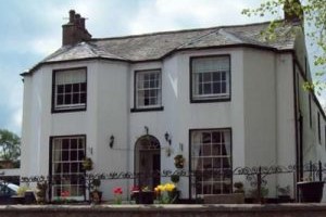 A warm Cumbrian welcome awaits you at Bongate House in Appleby. In addition to her seven fabulous rooms Anne has approximately an acre of garden for your enjoyment. Sit and enjoy the sun, or take a stroll to the end of the garden where hidden, beyond the trees, you will find a view of Appleby Castle and the River Eden. Visit their website
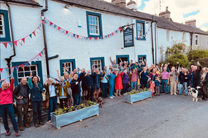 The Mardale Inn at Bampton Grange, saved by the Bampton Valley Community in 2022, is now a vibrant hub for locals and visitors alike. With six refurbished bedrooms and a welcoming atmosphere, guests can enjoy Cumbrian ales, delicious food, and a true sense of community spirit in this charming and historic inn. Visit their website
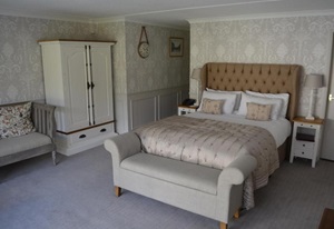 The Inn at Grasmere blends modern comforts with historic charm in the heart of the Lake District. Centrally located in the picturesque village of Grasmere, it offers breathtaking views and easy access to local attractions. Guests enjoy luxurious accommodations where timeless tradition meets contemporary hospitality in a truly iconic setting. Visit their website
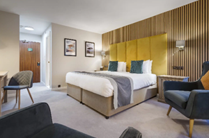 Crooklands Hotel blends decades of tradition with a fresh, modern feel. This family-run establishment has welcomed guests for over 40 years and with new ownership, recently underwent thoughtful refurbishment. With comfortable rooms, updated spaces, and warm, attentive service, Crooklands offers a relaxed and inviting base. Visit their website
General travel information on the Westmorland Way area will be in your holiday pack including train and bus timetables where available.
Detailed instructions on getting to your first night’s accommodation by car, or on foot from the nearest train or bus station, will also be included in the holiday pack on individual accommodation maps.
To view train times please visit trainline where you can also purchase tickets in advance. For information on bus timetables please visit traveline
If you require secure car parking whilst walking this route, please contact us for information.
Getting to Appleby:
By Air: The nearest international airports are Manchester (MAN) or Newcastle (NCL). You can then travel by train to Appleby (approx 3 hours from both). When traveling from Newcastle airport, take the Metro rail to the city centre railway station – the airport has its own Metro station (you will need some change for the ticket machine). The journey time from the airport to Newcastle Central Station is around 20 minutes.
By Public Transport: Appleby has a railway station which connects with all major railway lines.
By Road: Appleby in Westmorland is situated in the county of Cumbria. The M6 and A66 both pass in very close proximity. If you travel on the M6 to Penrith, Appleby is just 14 miles along the A66.
Returning from Arnside:
By Public Transport: Arnside has a railway station for connections with the west coast rail line.
By Road: From Arnside take the B5282 to the A6 and then join the M6.
Patterdale
Patterdale offers spectacular scenery in a peaceful location. This tiny village in the heart of the English Lake District will give you a well earned rest before heading onwards on your walking route. Boat trips can be taken on the Ullswater Steamers to Pooley Bridge, with several opportunities to disembark and explore the lakeshore attractions along the way.
Grasmere
Grasmere is a charming village right in the heart of the Lake District National Park and a great location to spend a well earned rest day. It was once the home of the famous poet William Wordsworth and today you can visit two of his former homes - Dove Cottage and Rydal Mount. In the centre of Grasmere is St. Oswald’s Church, which contains the Wordsworth family graves. The village itself has narrow bustling streets with cafes, shops and pubs. The frequent local bus service connects Grasmere with Keswick and Ambleside if you want to explore further into the Lakes.
| Prices | CAD ($) |
|---|---|
| Accommodation, map & guidebook only | $2360 |
| with Luggage Transport | $2704 |
| with Packed Lunches | $2558 |
| with Luggage & Lunches | $2886 |
Other Options |
|
| Extra Nights (per night) | $181 |
| Single Supplement (per night) | $114 |
| Solo Luggage Supplement (per day) | $38 |
