Walking Holidays in Southern England
Walking in Southern England invites you to immerse yourself in some of the most scenic and varied landscapes the UK has to offer. From peaceful country lanes and charming villages to dramatic chalk cliffs, this region has something for every walker. Discover ancient woodlands, historic landmarks, and rolling hills as you explore iconic routes through the likes of the Cotswolds, South Downs and the Chiltern Hills. Along the way, uncover centuries of history - from Bronze Age sites to the vital role of the Thames river - while enjoying breathtaking views and a warm, welcoming atmosphere that makes each walk truly special.
The Cotswold Round is a 59 mile circular walk from Cheltenham, through some of the most picturesque towns and villages in the Cotswolds. With rolling hills, and lovely market towns, this gentle route perfectly showcases the quintessential English countryside.

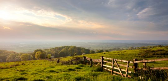
Picture a place of gentle hills and gorgeous stone villages. A place of honey coloured houses and luscious green meadows. A place of hedge lined country lanes. Picture this, and you have the Cotswolds. Our Cotswold Round is a circuit of some of the most picturesque towns and villages the Cotswolds has to offer. Their very names themselves an invitation to the inquisitive – Moreton-in-Marsh, Stow-on-the-Wold, Bourton-on-the-Water. Almost all of the round falls within the Cotswolds Area of Outstanding Natural Beauty. Covering over 2000 square kilometers, it’s the largest such protected area in England and Wales. Only Cheltenham lies outwith the boundary. On your journey you will walk through many nature reserves as well as Sites of Special Scientific Interest.
Cowslips carpet the grassland in spring and in summer look closely for the pyramidal orchid and bee orchid. Bluebell woods bring vibrant colour and sweet smelling lily of the valley fills air. The red kite and the skylark occupy the Cotswold sky. Rare butterflies flit from flower to flower and fortunate walkers may get to see a duke of burgundy or adonis blue. The ever present golden stone you’ll see is Oolitic limestone, formed sometime around 150-200 million years ago, when the Cotswolds were covered by a warm sea. Hundreds of Cotswold villages are built entirely of this stone. Consequently the Cotswolds have more protected or listed buildings than any other region. You may spot some Cotswold Lions, these shaggy sheep are bred in small numbers today, but were once the foundation of England’s wool trade with Europe. An industry amounting to almost 50% of the country’s economy. The magnificent churches you’ll see, many disproportionate in size to the villages they serve, were known as wool churches, constructed or enlarged by huge contributions from the wealthy wool merchants.
Accompanied by the sight of wildflowers and the sound of birdsong, this is a country walker’s dream. A mix of open meadow, track, woodland, river bank and country lane combine to make our 59 mile Cotswold Round a relaxing walk through what you’ll no doubt come to remember as quintessentially English countryside.
Length
5 - 8 nights
Full Route Length
59 miles / 95 km
Shortest Break Length
45 miles / 73 km
Average Grade
Easy to Moderate
Why do this walk?
Walk in England’s largest Area of Outstanding Natural Beauty.
Visit Belas Knap, one of Britain’s finest Neolithic long barrows.
A chance to see rare butterflies and orchids.
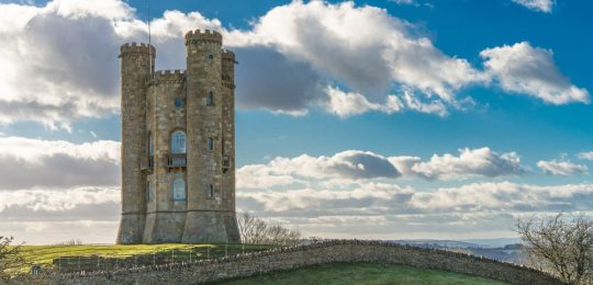
Enjoy panoramic views from Cleeve Common and Broadway Hill.
Admire the incredible architecture of the wool churches.
Enjoy nature reserves and Sites of Special Scientific Interest.
The Cotswold Way is a 102 mile walk from Chipping Campden to Bath, passing through picturesque Cotswold villages, rolling hills, and ancient woodlands. This route features stunning views, historic sites, and the chance to explore the World Heritage City of Bath.

The Cotswold Way is a much-loved walk that stretches 102 miles from the medieval market town of Chipping Campden in the North Cotswolds to the historic City of Bath. Following the western edge of the Cotswold Hills, the trail journeys through gently rolling, sheep-grazed pastures, stunning beech woodland, and dreamy, honey-coloured villages built from the delightfully warm Cotswold stone.
You will cross ancient commons in an Area of Outstanding Natural Beauty, pass Neolithic burial barrows, beautiful stately homes, and historic battle sites. The path along the escarpment twists and turns, affording ever-changing views to the west towards the River Severn and the Malvern Hills.
Along the way, you’ll pass some of the Cotswolds’ most captivating historical sites. Sudeley Castle stands as a testament to the region’s royal past, while the ancient Belas Knap Long Barrow offers a direct connection to the Cotswolds’ Neolithic inhabitants. The Tyndale Monument, dedicated to the 16th-century scholar William Tyndale, commemorates his legacy and his role in making the Bible accessible to English speakers. Each of these sites, along with others scattered along the trail, ties the natural beauty of the area to centuries of human history and achievement.
The Cotswolds countryside is a haven for wildflowers, birds, and insects. In springtime, expect to see cowslips and hope to spot orchids. Carpets of bluebells colour the woodlands, sweet with the scent of lily of the valley. When walking through meadows, watch out for rare butterflies such as the Adonis Blue or the Duke of Burgundy, and high above you’ll spot the Skylark and the Red Kite.
If it all sounds like a scene from a picture postcard, then it’s because it is. Quite simply, it’s incredibly idyllic, it’s quintessentially English, and it’s an absolute delight to walk.
Length
6 - 12 nights
Full Route Length
100 miles / 161 km
Shortest Break Length
47 miles / 76 km
Average Grade
Easy to Moderate
Why do this walk?
A gentle introduction to long-distance walking along one of the best way-marked National Trails in the country.
Sublime scenery, from gently rolling countryside to quintessentially English villages, with beautiful churches and cosy Cotswold Inns.
Steeped in history, you will encounter Medieval Wool Towns, Neolithic Burial Barrows, ancient abbeys and stately homes.
Spot wildflowers, butterflies, and birds in this protected Area of Outstanding Natural Beauty.
Follow the escarpment for ever-changing views over the Severn Valley and the Malvern Hills.
Visit the UNESCO World Heritage Site of Bath with its Roman remains and Georgian Architecture.
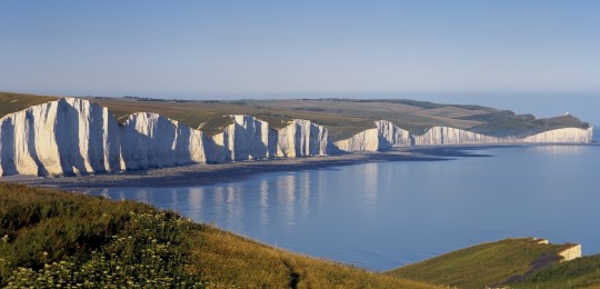
The Isle of Wight Coastal Path is a 72 mile circular route from Cowes. With dramatic coastal cliffs, sandy beaches, and tranquil woodlands, this walk offers a diverse and stunning exploration of the island’s natural beauty.

For those who love to stride out amid the fragrance of salty sea air and with the warmth of the sun on their face, the Isle of Wight Coastal Path is a dream come true.
Shaped like a diamond, the Isle of Wight really is a jewel in the English Channel, and our Coastal Path holidays are the perfect way to explore the island the Romans first named Vectis.
Our 72 mile circuit of the island begins in the seaport town of Cowes on the west bank of the River Medina. Cowes is home to the oldest and biggest sailing regatta in the world. From here we head south west to the historic town of Yarmouth, skirting Newtown National Nature Reserve as we go. Then it’s onwards to the village of Totland with its picturesque sandy beach, ahead of a breathtaking crossing of Headon Warren where you’ll catch your first glimpse of the iconic chalk stacks, The Needles, guarded by its lighthouse at the outer western end of the formation.
The grassy, whale backed ridge of Tennyson Down leads us east along the southern edge of the island, first past the chalk pebbled Freshwater Bay, then on to a collection of chines and home to one of the richest areas for dinosaur discovery in Europe. St Catherine’s Lighthouse marks the most southern point of the island and is one of the oldest lighthouse locations in Great Britain.
Shanklin, Sandown and Seaview continue the theme of sun, sea and sand. Ryde, home to the world’s oldest hovercraft operator, is now all that stands between you and the completion of your circuit.
The island has been home to Alfred Lord Tennyson, Charles Dickens, Charles Darwin and Queen Victoria. Also, thanks to Italian inventor Guglielmo Marconi, the birthplace of the radio. The Isle of Wight is also England’s largest island. Yet at high tide, becomes England’s smallest county!
Put simply, if you love the thought of walking round a beautiful and fascinating island, that enjoys more sunshine than some parts of Spain, then the Isle of Wight Coastal Path is most certainly the holiday for you.
Length
5 - 8 nights
Full Route Length
72 miles / 116 km
Average Grade
Easy to Moderate
Why do this walk?
The island is designated a UNESCO Biosphere Reserve.
Marvel at the iconic chalk edge ‘The Needles’ with its 33-metre-high lighthouse.
Stride out over the whale-backed ridge of Tennyson Down.
More than half the Island is a designated Area of Outstanding Natural Beauty.
The Isle of Wight enjoys more sunshine than some parts of Spain.
The island is home to some of the richest cliffs and quarries for dinosaur fossils in Europe.
The Peddars Way and North Norfolk Coast Path is a 93 mile walk from Knettishall Heath to Cromer, passing through the peaceful Norfolk countryside and along the North Norfolk coastline. This route offers a perfect blend of countryside and coastal beauty.

The Peddars Way and the North Norfolk Coast Path combine to make a very accessible 93 mile walk, taking in the very best of the Norfolk countryside and coastline.
The Peddars Way is an ancient road dating back to the Bronze Age, which was later developed into a military route in Roman times and was later used by pilgrims during the 15th century. The 45 mile route is for the most part straight and relatively flat, following mostly green lanes and tracks, with some interesting archaeological sites along the way. Castle Acre priory and castle are worth a visit as well as the Bailey Gate, this dates back to 1200 and the road into the village still leads through the gate today.
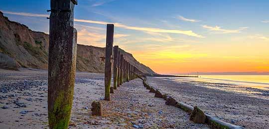
The North Norfolk Coast Path follows the coastline for 45 miles from Hunstanton to Cromer, passing through Victorian seaside towns, charming fishing villages, beautiful beaches, and nature reserves with a wealth of birdlife. This easy-to-follow trail offers plenty to see, with fresh seafood stalls along the way enhancing its coastal charm. The Norfolk coast is perhaps a little less known than many parts of the northern coast and, as a result, remains quieter and more unspoilt, which only adds to its appeal.
These are by their very nature, one countryside and one coastline, two very differing landscapes, but what they share in common is that they are places of peace and tranquillity. Enjoy them as separate short breaks or combine them into one amazing adventure, either way you are guaranteed a truly memorable experience.
Length
4 -10 nights
Full Route Length
93 miles / 149 km
Shortest Break Length
45 miles / 72 km
Average Grade
Easy to Moderate
Why do this walk?
Walk an ancient route steeped in history, from Roman roads to medieval pilgrimage trails.
Spot seals, wading birds, and a wealth of wildlife along this unspoilt coastline.
Discover historic villages, medieval churches, and the impressive ruins of Castle Acre Priory.
Experience the charm of traditional beach huts, dunes, and pine-backed shorelines.
Spot a variety of birdlife on Brettenham Heath, a haven for wildlife enthusiasts.
Enjoy the tranquillity of a quieter, less-travelled National Trail, perfect for peaceful exploration.
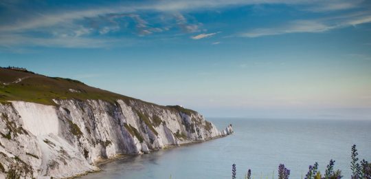
The South Downs Way is a 104 mile walk from Winchester to Eastbourne, passing through the rolling hills of the South Downs and ending at the dramatic chalk cliffs of the English Channel. This route features stunning views, charming villages, and dramatic coastal scenery.

The South Downs Way starts at the ancient and historic city of Winchester and follows the northern crest of the chalk escarpment of the South Downs, all the way to the sea. Stretching for 100 miles through England’s newest National Park, to the seaside town of Eastbourne, this walking holiday offers a fabulous taste of this lovely rural area, with spectacular views, expansive fields, beautiful woodlands, picturesque villages and a good helping of history.
The South Downs Way is well marked and easy to follow. It is used by horse riders and cyclists, so is very accessible, with almost no stiles. It links many ancient and historic tracks, used by travellers and traders since the Stone Age. It is one of the easier National Trails, with few steep sections, apart from when the route drops down into river valleys, and for the descent to overnight stays in the pretty towns, villages and farms along the way.
Although seldom exceeding 250m (820ft), this walk gives a real sense of space and a feeling of being ‘on top of the world’. You’ll pass Iron Age hill forts, the spectacular chalk formations of The Devil’s Dyke and the Seven Sisters, as well as rolling countryside dotted with fields of grazing sheep, corn, and wildflowers. This journey offers a magnificent sense of solitude, centuries of history, and a cross-section of one of the most beautiful parts of southern England, with sweeping panoramas from Winchester’s historic streets to Eastbourne’s dramatic coastline.
Length
3 - 10 nights
Full Route Length
104 miles / 167 km
Shortest Break Length
19 miles / 31 km
Average Grade
Moderate
Why do this walk?
Walk from Winchester to Eastbourne through England’s newest National Park.
Follow ancient trails used since the Stone Age by travellers and traders.
Explore picturesque villages, Iron Age hill forts, and historic landmarks.
Admire the dramatic chalk formations of The Devil’s Dyke and Seven Sisters.
Discover fields of wildflowers, grazing sheep, and cornfields along the way.
Relish the solitude and beauty of southern England’s tranquil landscapes.
The Thames Path is a 185 mile walk from its source just outside Kemble in the Cotswolds to the Thames Barrier in London. Passing through peaceful countryside, historic towns, and the vibrant city of London, this route offers a journey through diverse landscapes alongside England’s greatest river.

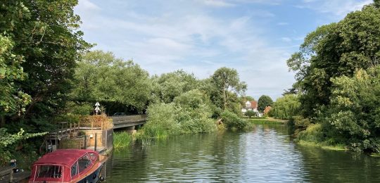
The Thames Path National Trail follows the greatest river in England for 185 miles from its trickling source just outside Kemble in the rural Cotswolds to its vast presence at the Thames Barrier, just a few miles before it meets the sea.
The River, once vital to trade, helped grow England’s capital to the bustling city it is today. However, as railways and roads took over, this great trading route began to decline. In the 1930s, discussions began on how to revitalise the old Thames towpath, but it wasn’t until 1996 that the Thames Path officially became a National Trail. After years of work by groups such as the Ramblers Association and the River Thames Society, 16 miles of new towpath were added, completing the route.
Now, it’s a celebrated long-distance trail – well signposted and accessible, with only one brief incline beyond Goring Gap. Despite this small climb, the Thames Path remains suitable for walkers of all abilities, offering an easy, enjoyable experience overall.
As you walk, the river evolves from its gentle beginnings to its mighty flow through London. You’ll encounter tranquil water meadows, an abundance of wildlife and wildflowers, as well as quaint villages, historic market towns, and iconic locks. Watch herons poised at the water’s edge, and ducks and swans glide by. In lively towns like Marlow, Henley, and Eton, rowers and pleasure boats add to the river’s charm, while in the quieter rural stretches, a community of brightly painted canal boats moves at its own unhurried pace.
Add rest days along the way to explore local sights, from the famous spires of Oxford and the grandeur of Windsor Castle to the peaceful beauty of Kew Botanical Gardens.
Length
3 - 21 nights
Full Route Length
185 miles / 298 km
Shortest Break Length
27 miles / 44 km
Average Grade
Easy to Moderate
Why do this walk?
Enjoy easy-to-follow gentle walking through idyllic rural landscapes with beautiful river views.
Experience the peaceful beauty of water meadows, nature reserves, and iconic locks along the way.
Explore historic towns such as Abingdon, Marlow, and Richmond upon Thames, each with its own unique charm.
Take time to visit local landmarks, including the spires of Oxford, Windsor Castle, and the peaceful Kew Gardens.
Follow in the footsteps of history along a trail that once served as a vital trading route for England.
Enjoy the lively atmosphere of rowing clubs and pleasure boats in towns like Henley and Eton.
The Ridgeway is an 87 mile walk from Avebury to Ivinghoe Beacon, passing through Wiltshire, Oxfordshire, Berkshire, Buckinghamshire, and Hertfordshire. Following ancient paths and offering expansive views over the countryside, it’s a journey through history, nature, and the heart of rural England.

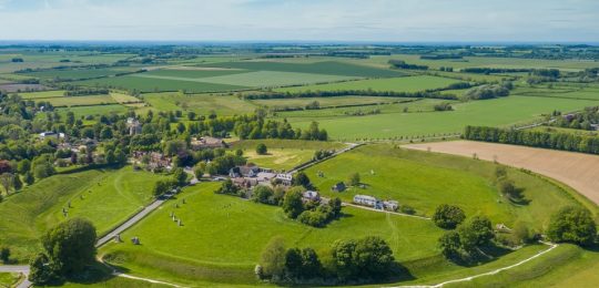
The Ridgeway National Trail runs for 87 miles from Overton Hill near Avebury to Ivinghoe Beacon just north of Aldbury. The entire length of the trail lies within two Areas of Outstanding Natural Beauty – the North Wessex Downs and the Chiltern Hills, and passes through no fewer than five of the greenest counties in England – Wiltshire, Oxfordshire, Berkshire, Buckinghamshire and Hertfordshire. The trail also visits a number of National Nature Reserves, home to a vast array of birdlife, butterflies and wildflowers.
With a history dating back some 5,000 years, The Ridgeway is the oldest road in Britain, perhaps even in Europe. A way for prehistoric man to travel across the land on higher and naturally drier ground. For thousands of years it was a drove road, used for the transportation of livestock and goods. From their elevated position travellers would benefit from the relative safety of being able to see any dangers around them. Today, it’s a place of leisure, where walkers, cyclists and horse riders can exercise and enjoy the stunning scenery on offer.
The North Wessex Downs and the Chiltern Hills offer two quite differing landscapes and walking experiences, yet remain really quite complementary. From the World Heritage Site at Avebury, the trail travels north east along the chalk downs with the reward of fine views stretching into the distance and the pleasure of walking on broad, springy grassland. The Ridgeway drops down to cross the River Thames at Goring before climbing into the Chiltern Hills. This a more diverse landscape of open downland, chalk escarpment, farmland and woodland, utilising a variety of footpaths, bridleways and tracks.
The Ridgeway isn’t simply a long distance walking trail, it’s a historic monument too, dating back to the Neolithic Age. Some of the earliest archaeological remains to be found on the trail include Avebury Castle and the long barrows at Wayland’s Smithy and West Kennett. The Iron Age brought impressive Hill Forts with Barbury, Segsbury and Pulpit Hill among those visited on the trail. Grim’s Ditch likely dates from this period too. There are many chalk carvings on the downs, the most famous of these, the Uffington White Horse, dating back 3,000 years to the Bronze Age.
Step back in time and follow those who for five millennia have worshiped upon and walked The Ridgeway.
Length
4 - 10 nights
Full Route Length
91 miles / 147 km
Shortest Break Length
42 miles / 68 km
Average Grade
Easy to Moderate
Why do this walk?
Soak up 5,000 years of history on Britain’s oldest road.
Walk within two designated Areas of Outstanding Natural Beauty.
Enjoy easy walking over the North Wessex chalk downs with far reaching views.
Enjoy a delightful patchwork of woodlands around the Chiltern Hills.
Spend time exploring in and around Avebury - part of the UNESCO Stonehenge and Avebury World Heritage Site.
Visit an array of Iron Age hill forts, long barrows, stone circles, and remnants of medieval villages.
Client Feedback
Read more >This was our 3rd walk with Mickledore and it fulfilled all our expectations. Meticulously planned and prepared, with everything working like clockwork. Really easy to deal with and helpful.
Read more >We have been on many walking holidays and have always used Mickledore. They are easily contactable. Provide superb information and only book good B&Bs, which they check regularly. What we like most is that they themselves do the walks, so they know exactly what they are like.
Read more >A once in a lifetime experience walking the West Highland Way.
Loved it.
No worries, just walk!
Mickledore organised my holiday perfect.