Walking Holidays in Northern England
Northern England offers an incredible variety of walking holidays, from dramatic coastlines and rolling countryside to historic trails steeped in heritage. Whether you’re drawn to the rugged beauty of the North York Moors and the Yorkshire Dales, the sweeping beaches and castles of the Northumberland coast, or the challenge of classic long-distance routes such as the Coast to Coast and the Pennine Way, there’s something for every walker. Explore moorland and farmland, follow scenic valleys, or immerse yourself in Roman history along Hadrian’s Wall - wherever you choose to walk, you’ll experience landscapes rich in character and charm.
The Cleveland Way is a 100 mile walk from Helmsley, on the edge of the North York Moors, to Filey on the east coast. This scenic route combines heather-clad moorland with dramatic coastal cliffs, offering a journey through some of Yorkshire’s most striking landscapes.

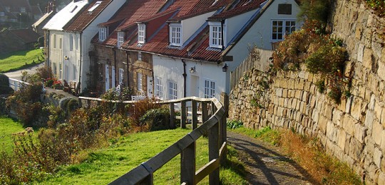
The Cleveland Way, established in 1969, is both an interesting and beautiful path. It stretches for over 100 miles from Helmsley, on the southern edge of the North York Moors National Park, to Filey on the east coast.
The way passes through two very distinct types of landscape. From Helmsley to Saltburn-by-the-Sea, it traverses classic moorland scenery, through forests and along escarpments, rewarding you with panoramic views over the Cleveland Hills and the rest of the National Park.
In the beautiful Rye Valley you can marvel at the ruins of Helmsley Castle and the medieval Rievaulx Abbey. Ahead of Sutton Bank take time to view the magnificent Kilburn White Horse. Roseberry Topping, often referred to as the Yorkshire Matterhorn is a wonderful viewpoint. Despite its relatively low height of 1000 feet it is a tremendous place from which to survey the land around you.
The other half of the route, from Saltburn-by-the-Sea to Filey, follows a dramatic coastline and runs along the top of some of the highest sea cliffs in the country. Whitby, with its fine harbour, fossil-filled cliffs and connections with Bram Stoker’s Dracula is a favourite of many and a visit to the imposing remains of Whitby Abbey is a must. Robin Hood’s Bay, the end point of the Coast to Coast and the seaside towns of Scarborough and Filey complete your coastal journey.
The combination of wild moorland and dramatic coastline make the Cleveland Way an incredibly varied, thoroughly enjoyable and hugely rewarding experience.
Length
6 - 12 nights
Full Route Length
110 miles / 177 km
Shortest Break Length
51 miles / 82 km
Average Grade
Moderate
Why do this walk?
Walk through two distinct landscapes, from sweeping heather moorland to dramatic coastal cliffs.
Marvel at the medieval ruins of Helmsley Castle and Rievaulx Abbey.
Enjoy breathtaking views from the dramatic Sutton Bank escarpment.
Summit Roseberry Topping, the Yorkshire Matterhorn, for a rewarding panorama.
Follow high sea cliffs from Saltburn to Filey, with spectacular coastal views.
Explore Whitby’s historic harbour and the atmospheric ruins of Whitby Abbey.
The Coast to Coast is a classic long-distance walk spanning 193 miles from St Bees on the Irish Sea to Robin Hood’s Bay on the North Sea. Crossing the Lake District, Yorkshire Dales, and North York Moors, it showcases England’s most spectacular and varied landscapes.

The Coast to Coast walk was created by the celebrated fell walker and guidebook writer Alfred Wainwright. Probably best known for his legendary Pictorial Guides to the Lakeland Fells, Wainwright completed his trek across the width of England in 1972. The following year, the Westmorland Gazette published his handwritten guide. Since then the Coast to Coast Path has established itself as one of England’s classic long distance walks. It travels 193 miles, from the sea cliffs of St Bees on the Irish Sea, to the fishing village of Robin Hood’s Bay on the North Sea. The quality and variety of this walk is recognised internationally, with walkers travelling from around the globe to complete the walk.
As the route traverses the country, your two-week journey will take you through three national parks and over a cross-section of England’s most dramatic landscapes. You’ll walk among the highest fells and alongside the largest lakes, through delightful woodland and over windswept moorland.
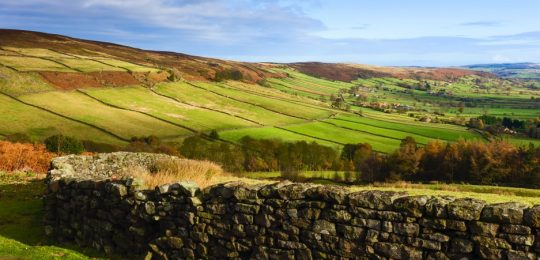
The Coast to Coast begins in the Lake District, taking in deep sided valleys, lake shores and tough mountain passes. There are a number of considerably steep sections here that will certainly test your stamina. Thankfully there’s a fine selection of tea rooms and cafés where you can treat yourself to a well-deserved reward. Next is the limestone country of the Yorkshire Dales, famous for its intricate field patterns and dry stone walls. The Dales topography is less extreme than that of the Lakes. The old market town of Richmond marks the end of the Dales, before the path crosses the Vale of York and rises over the sometimes remote, moorland hills of the North York Moors.
Sufficiently challenging and hugely rewarding, it’s little wonder that, more than fifty years after its conception, the Coast to Coast remains one of the most popular long distance walks in England.
Length
6 - 18 nights
Full Route Length
193 miles / 311 km
Shortest Break Length
84 miles / 135 km
Average Grade
Challenging
Why do this walk?
Follow in the footsteps of Alfred Wainwright on England’s most famous long-distance trail.
Cross three national parks - the Lake District, Yorkshire Dales, and North York Moors - in one epic journey.
Begin at the dramatic sea cliffs of St Bees and finish at Robin Hood’s Bay, dipping your boots in both seas.
Enjoy welcoming villages, charming pubs, and traditional tearooms - ideal for refuelling along the way.
Discover centuries of history, from ancient stone circles to Norman castles and abbeys along the way.
Enjoy the challenge of crossing Kidsty Pike, the highest point on the Coast to Coast.
The Dales High Way is a spectacular 94 mile high-level route from the UNESCO World Heritage Site of Saltaire to Appleby-in-Westmorland. Passing over the high ground of the Yorkshire Dales and the Howgills, it offers breathtaking views and a rewarding challenge for strong walkers.

The Dales High Way is a hillwalkers paradise. Stretching 94 miles from Saltaire in West Yorkshire to Appleby in Cumbria, the High Way, as the name suggests, follows the glorious high ground over the West Yorkshire Moors, the Dales limestone country, and the Howgill Fells.
The route begins in the village of Saltaire, a UNESCO World Heritage Site. In the mid-19th century, on the banks of the River Aire, textile manufacturer Sir Titus Salt built not only his woolen mill, but also a village; with houses for his workers, and bath houses, a hospital, an institute for recreation and education, a school for the workers children and even a concert hall. Saltaire is a fascinating place worthy of thorough exploration.
The High Way itself could be described as having three quite differing landscapes. The first of these being the peaty, heather-clad moors that continue pretty much to fringes of Malhamdale. Your introduction to these is Rombalds Moor, a collective name for a number of local moors named according to the nearest town, such as Burley, Bingley and most famous of them all, Ilkley Moor.
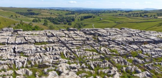
On reaching Malhamdale you enter classic Dales limestone country, where there is almost as much going on beneath the ground as there is above it. Few places demand an additional day as much as Malham does. A day exploring Janet’s Foss, Gordale Scar and Malham Tarn is a day well spent. The Dales also offers up some of the most challenging terrain on the High Way, including the crossing of the mighty Ingleborough and the temptation of climbing Yorkshire’s highest peak, Whernside.
The final phase of the walk involves a traverse of the entire Howgill range in a tremendous six mile ridge walk. The imposing Howgills are a series of steep sided, round topped, grassy hills that fold smoothly into one another. The reward for your efforts are far reaching views taking in the likes of the Mallerstang-Garsdale Fells, the Yorkshire Three Peaks, the Lakeland Fells and the North Pennines. Once off the tops all that remains is a celebratory walk through the beautiful Cumbrian countryside, and with the hard work behind you, a chance to reflect on all that you’ve achieved and enjoyed on the incredible Dales High Way.
Length
5 - 10 nights
Full Route Length
94 miles / 151 km
Shortest Break Length
38 miles / 61 km
Average Grade
Moderate to Challenging
Why do this walk?
Explore the village of Saltaire, a designated UNESCO World Heritage Site.
Discover standing stones, prehistoric rock carvings and a Bronze Age stone circle on Ilkley Moor.
Take the opportunity to explore Malhamdale - Janet’s Foss, Gordale Scar and Malham Cove.
Walk over Ingleborough, one of the magnificent Yorkshire Three peaks.
Traverse the entire length of the Howgill Fells in a tremendous six mile ridge walk.
Return to the start on the iconic Settle to Carlisle railway line.
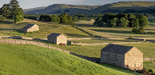
The Dales Way is an 81 mile walk from Ilkley in West Yorkshire to Bowness-on-Windermere in the Lake District. Following riverside paths and limestone pavement, it provides a gentle and picturesque journey through the heart of the Yorkshire Dales.

The Dales Way crosses through the internationally renowned Yorkshire Dales National Park from east to west, spending much of its time on the riverside paths bordering the Rivers Wharfe and Dee. The 81 mile route begins in the market town of Ilkley on the eastern edge of the Dales and travels through Wharfedale and Dentdale, before crossing into the foothills of the Lake District National Park to finish on the shores of Lake Windermere, England’s largest lake.
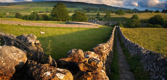
This is primarily a riverside walk through a characteristic landscape of limestone dry stone walls and isolated field barns with small villages and hamlets dotted through beautiful and peaceful steep sided valleys. Short sections of windswept peaty moorland and iconic limestone pavement add variety.
Few places, if indeed any, are as pretty as the Dales, particularly in spring and summer when the trees are in leaf, the meadows are brightly decorated with wildflowers and the songbirds are at their most active.
The trail is rarely far from a river bank and the water is home to the ever-present mallard, occasionally joined by moorhen. Perched on rocks are an assortment of attractive little birds such as brown and white dippers and pied and yellow wagtails. Keeping watch over the bank will be the heron. More difficult to spot, but certainly around will be weasels and stoats. There are deer in the woods, if you are both quiet and patient, you may be lucky enough to spot them. On the uplands, with their song often heard before they are seen, are the skylark, peewit and lovely meadow pipit.
What the Dales Way does best, in addition to serving up mile upon mile of idyllic countryside, is it gains you easy access to some of the most striking scenery in the north of England. For a time, as you transition from Yorkshire Dales to Lake District, you’ll have the enormous and rounded Howgill Fells towering above you, and a stunning skyline of rugged Lakeland mountains laid out ahead of you. Simply magnificent!
Length
7 - 9 nights
Full Route Length
81 miles / 130 km
Average Grade
Easy to Moderate
Why do this walk?
Walk alongside the River Wharfe and River Dee, with their tranquil waters and abundant wildlife.
Explore classic Dales landscapes, with dry stone walls, limestone pavements, and wildflower-filled meadows.
Wander through charming villages and market towns, full of local character.
Skirt the magnificent Howgill Fells, one of the quietest corners of Cumbria.
Spot an array of birdlife, from dippers and wagtails on the riverbanks to skylarks and meadow pipits in the uplands.
Finish on the shores of Lake Windermere, England’s largest lake, with its spectacular mountain backdrop.
Hadrian’s Wall Path is an 86 mile National Trail following the line of the Roman wall from Wallsend near Newcastle to Bowness-on-Solway. This historic route crosses the rugged landscapes of northern England, offering a fascinating mix of history and stunning scenery.

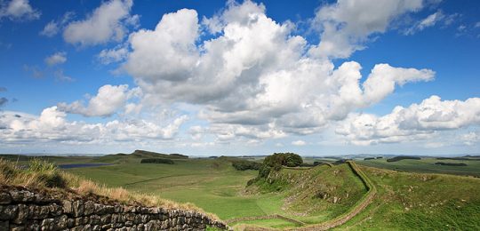
Hadrian’s Wall Path, opened in 2003, was an immediate success with walkers from both the UK and abroad. The route follows the course of northern Europe’s largest surviving Roman monument, built on the orders of Emperor Hadrian between AD122 and AD128 to protect the northern extreme of the Roman Empire.
The path crosses the country coast to coast from Wallsend, near Newcastle, through the rolling border countryside of Northumberland, continuing on to the historic city of Carlisle and finally to the flat plains of the Solway Coast.
Hadrian’s Wall Path was the first National Trail to follow the course of a UNESCO World Heritage Site. To ensure that the integrity of the Wall was in no way compromised, an archaeologist was on hand each time a signpost or waymark was driven into the ground. As a consequence, it took ten years to open the path to the public – four years more than it took the 2nd and 6th legions of the Roman Army to build the actual wall. However, anyone who has ever walked the trail will testify, it was well worth the wait.
The most dramatic section of the walk is in the centre, where the landscape is at its most impressive, and large stretches of the wall still remain. Here, you’ll also find some of the best-preserved fortresses. It’s easy to imagine how these windswept moors looked centuries ago, as the Wall, punctuated by forts, milecastles, and turrets, snaked its way through the undulating Northumberland countryside. This wilderness is bookended by the bustling City of Newcastle on the east, and on the west the breathtakingly beautiful plains at Bowness on Solway, an area of outstanding natural beauty and a haven for birdwatchers.
With the Romans long gone, the wall fell into disrepair, and much of the stone became the fabric of the churches, abbeys and priories you see today. The Wall’s legacy lives on in the names of the towns and villages along the route; Wallsend, Wallhouses, Walton and even Oldwall being just a few examples.
Despite a few undulating sections, the path itself is considered one of the easier national trails, a route where you can spend a week on well-trodden paths marvelling at the fascinating remains and the stunning scenery around you.
Length
4 - 11 nights
Full Route Length
86 miles / 138 km
Shortest Break Length
24 miles / 39 km
Average Grade
Easy to Moderate
Why do this walk?
Follow the most extensive Roman remains in the world from Coast to Coast.
An easy to follow trail with well-trodden paths and clear waymarking.
Explore historic sites such as Chesters, Housesteads, Vindolanda, and Birdoswald.
See how history shaped the landscape, with churches, priories, and barns built from the Wall’s stone.
Experience wildlife sightings, including red squirrels, deer, and a variety of birdlife in the surrounding woodlands.
Explore the breathtaking Solway Coast, a haven for birdwatchers and a beautiful finish to your journey.
The Herriot Way is a 52 mile circular route from Aysgarth, through Wensleydale and Swaledale in the Yorkshire Dales. Passing over high fells, through picturesque villages, and across heather-covered moors, it captures the essence of this beautiful and unspoiled region.

The Herriot Way is a 52 mile circular route that takes you through some of the most breathtaking landscapes in the Yorkshire Dales. Inspired by a walk taken by the beloved veterinarian and author James Herriot, the trail follows in the footsteps of his everyday life and the places he cherished, made famous in his books ‘All Creatures Great and Small’ and ‘James Herriot’s Yorkshire’.
Starting and ending in the charming village of Aysgarth in the heart of Wensleydale, famous for its cheese as well as its stunning waterfalls, the route takes you through Hawes, the highest market town in Yorkshire, and into the tranquil beauty of Swaledale. Here, wildflower meadows, limestone barns, and dry stone walls paint the landscape, offering endless photo opportunities.
As you journey along, you’ll be treated to lush green valleys, quiet country lanes, peaceful riversides, and heather-clad moorlands. The walk also reveals glimpses of the area’s industrial past, passing by historic monuments, disused railways, and picturesque villages that speak of a simpler time.
The Herriot Way is the perfect choice for those who want to explore the heart of the Dales, with every step offering something new – whether it’s a spectacular view, a quiet moment by a river, or a reminder of the region’s rich heritage. It’s a journey that blends the beauty of nature with the charm of days gone by.
Length
5-6 nights
Full Route Length
52 miles/ 83km
Average Grade
Moderate
Why do this walk?
See the stunning parts of the Yorkshire Dales described by James Herriot in his books ‘All Creatures Great and Small’ and ‘James Herriot’s Yorkshire.’
Enjoy a mix of landscapes, from gentle riverside paths to heather-clad moorland with sweeping views.
Visit Hardraw Force, the highest single-drop waterfall in England, and Aysgarth Falls, the impressive triple-drop waterfall.
Explore beautiful Dales villages such as Thwaite, Reeth and Askrigg.
Walk through Swaledale, with its wildflower meadows, dry stone walls, and iconic limestone barns.
Visit the home of Wensleydale Cheese in the market town of Hawes.
Lady Anne’s Way is a 100 mile walk from Skipton to Penrith, following in the footsteps of Lady Anne Clifford. Passing through the Yorkshire Dales and the Vale of Eden, it links historic castles with a journey through rolling moorlands and peaceful valleys.

Lady Anne’s Way is a classic long distance walk extending for 100 miles from the rugged limestone countryside of the Yorkshire Dales, to the unspoilt villages of the Eden Valley. The trail was conceived as a tribute to Lady Anne Clifford, who devoted her life to the restoration of her castles, churches, and monuments along this route in the 17th century. From Skipton Castle in North Yorkshire the path runs north to the ruins of Brougham Castle on the outskirts of Penrith.
The Way takes in sections of the Dales Way in Wharfedale and the ancient green lane known as Lady Anne’s Highway along Mallerstang, visiting Lady Anne’s historically significant buildings along the route. The varied nature of this trail makes it appealing to both seasoned walkers and those seeking their first experience of a long distance hike.
Starting with easy walking along the banks of the River Wharfe, the route then takes a high path over the fells from Wensleydale into Mallerstang with its wild and dramatic scenery. Upon entering the Eden Valley, the trail follows softly flowing rivers from Kirkby Stephen to Appleby, passing through scenic villages before reaching Penrith.
In addition to its many castles, churches, and monuments, the moorlands and meadows of Lady Anne’s Way are home to golden plovers and skylarks, while red kites and peregrine falcons may also make an appearance. When walking by slow-flowing water, look out for kingfishers. At dawn and dusk, move quietly and keep an eye out for foxes and badgers, while in woodland, watch for red squirrels and great spotted woodpeckers.
Whether you’re drawn to the rich history of Lady Anne Clifford’s legacy, the stunning natural landscapes, or the variety of wildlife along the way, Lady Anne’s Way offers a memorable and rewarding walking experience.
Length
6 - 10 nights
Full Route Length
100 miles / 161 km
Shortest Break Length
56 miles / 90 km
Average Grade
Moderate
Why do this walk?
Explore a landscape rich in history, passing castles, churches, and monuments linked to Lady Anne’s legacy.
Walk through the wild and dramatic valleys of Wensleydale and Mallerstang in the Yorkshire Dales.
Enjoy the peaceful charm of the Eden Valley, with its rolling countryside and scenic riverside trails.
Spot red kites, peregrine falcons, and golden plovers soaring above the fells.
Stroll through unspoilt villages and historic market towns, each with its own unique character.
End your journey at the impressive Brougham Castle, a fitting finale to this remarkable trail.
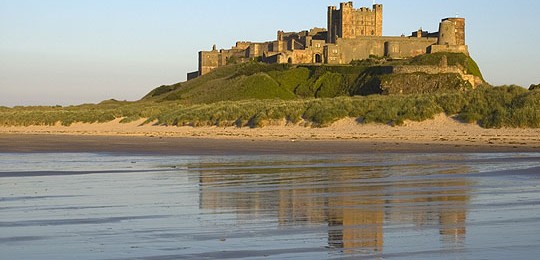
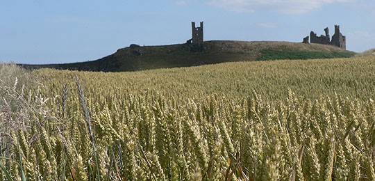
The Northumberland Coast Path is a 63 mile walk from Cresswell to Berwick-upon-Tweed. Known for its sweeping beaches, imposing castles, and dramatic cliffs, it offers a stunning journey along one of England’s most beautiful stretches of coastline.

The Northumberland Coast is renowned for its sweeping beaches, spectacular castles, rolling dunes, dramatic rock formations and isolated islands. Amidst this striking landscape is the evidence of an area steeped in history, spanning 7,000 years of human activity. A host of conservation sites, including two National Nature Reserves, testify to the immense variety of wildlife and habitats also found on this stunning stretch of coast.
The 64 mile route for the most part hugs the coastline, only making a detour inland between Belford and Fenwick. The terrain is generally level and as such, in clear weather, you’re rewarded with tremendously far reaching views. The majority of the paths are public rights of way, however in places beaches, minor roads and permissive paths are used.
You will journey along a wild and empty expanse of endless beaches punctuated by some of the most imposing castles in England – Warkworth reflecting magnificently in the River Aln, the dramatic ruins of Dunstanburgh, the most majestic of all Bamburgh, and the remains of the once great castle at Berwick-Upon-Tweed, famous for its Elizabethan town walls. Each has a remarkable history and is worthy of thorough exploration.
Also deserving of exploration are the offshore attractions of Coquet Island, the Farne Islands and the Holy Island of Lindisfarne. Consider factoring in a rest day or two when planning your adventure.
Nature lovers will delight in the Northumberland coast. On the river estuaries you’ll find wading birds such as ring plovers and oyster catchers, wetlands host egrets, herons, and a variety of waterfowl, while the offshore islands are home to puffins, razorbills and guillemots. The dune systems, saltmarshes and grasslands support an amazing array of plant life including the southern marsh orchid, marsh helleborine, sea campion, common rock-rose and fairy flax.
With its sweeping beaches, dramatic landscapes, and abundance of wildlife, this coastal walk presents a chance to immerse yourself in an area where history and nature blend seamlessly.
Length
5 - 7 nights
Full Route Length
63 miles / 101 km
Average Grade
Easy to Moderate
Why do this walk?
A string of dramatic castles along the coast punctuate your walk.
Walk along vast, unspoilt beaches with breathtaking views stretching to the horizon.
Enjoy gentle, easy walking on well-marked trails with stunning scenery at every turn.
Wander through rolling dunes, saltmarshes, and coastal wildflower meadows teeming with life.
Enjoy splendid views out to Coquet Island and the Farne Islands.
Take in the historic charm of Berwick-upon-Tweed, with its Elizabethan town walls and riverside views.
The Pennine Way is a challenging 265 mile National Trail from Edale in the Peak District to Kirk Yetholm in the Scottish Borders. Following the Pennine spine, it passes through remote moorlands, dramatic uplands, and some of the wildest landscapes in England.

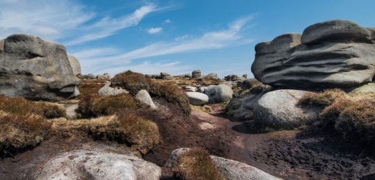
The Pennine Way is Britain’s oldest and perhaps most iconic National Trail. Every long-distance walker will, at some stage in their lives, no doubt have this famous route in their sights. Stretching some 265 miles along the backbone of England and into the Scottish Borders, the Pennine Way passes through three national parks and a vast Area of Outstanding Natural Beauty as it takes you on a tour of some of the most scenic upland landscapes in the country.
The trail begins in the picturesque village of Edale in the Derbyshire Peak District and winds its way north along the Pennine spine crossing wild and desolate moorlands, through charming dales, over rugged limestone hills, and even on historic Roman roads, finally reaching the Scottish Borders and the town of Kirk Yetholm. The rewards for taking up the challenge of the Pennine Way are plentiful; the sight of the dramatic Kinder Scout plateau, the limestone cliffs of Malham Cove, the awe-inspiring High Force waterfall, the magnificent High Cup Nick, the best-preserved stretch of Hadrian’s Wall and the sweeping vistas from the Cheviot Hills to name but a few.
Delightful though they are, don’t think for a moment that the Pennine Way is all heather-clad moorland and the cry of the curlew. These lands are rich with cultural and historical significance, shaped by centuries of human activity. Expect to see prehistoric monuments, Roman forts, and medieval packhorse routes. Take time to connect with the stories of those who have traversed these lands throughout history.
Completing the Pennine Way is both an amazing achievement and an unforgettable experience. Perhaps you are a seasoned long-distance walker looking to fulfil a long-held ambition, or maybe a nature lover, hoping to witness the ever-changing, untamed beauty of the countryside? Whatever your reason, the Pennine Way is sure to leave an indelible mark on all those who venture along its path.
Length
5 - 23 nights
Full Route Length
265 miles / 426 km
Shortest Break Length
68 miles / 109 km
Average Grade
Challenging
Why do this walk?
Enjoy the challenge of Britain’s oldest and most iconic National Trail.
Experience Kinder Scout, Bleaklow and Black Hill, some of the finest walking in the Dark Peak.
Marvel at High Cup Nick, a magnificent U shaped example of glacial erosion.
Explore the impressive Malham Cove and Watlowes dry valley.
Scale Cross Fell, the highest point on the Pennines, and the highest hill in England outside the Lake District.
Walk along the best preserved section of Hadrian’s Wall.
The Settle to Carlisle Way is a scenic 99 mile walk from Settle to Carlisle, following riverside paths beneath the Yorkshire Three Peaks and through the peaceful Eden Valley. With rolling countryside and railway heritage, it’s a relaxed and rewarding journey.

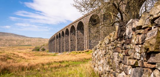
The Settle to Carlisle Railway is without doubt one of the most scenic rail journeys in the land. In an astonishing feat of Victorian engineering the line was built in just seven years and involved the construction of no fewer than 14 tunnels and more than 20 viaducts. The line has many remarkable landmarks, perhaps most notably Ribblehead Viaduct, spanning a distance of 400 metres and boasting 24 magnificent arches towering 30 metres above the ground.
For almost 150 years passengers have been enjoying the delights of the Yorkshire Dales and Eden Valley through their carriage windows. Now, thanks to the Settle to Carlisle Way, you can experience this same stunning landscape at a much slower pace.
From the limestone country of the Yorkshire Dales National Park to the pleasant farmlands of Cumbria’s Eden Valley, the Settle to Carlisle Way links together each of the stations along the much loved line. The terrain you walk over is as varied as landscapes you pass through. Fascinating limestone grassland, moorland tracks, enchanting woodland trails, riverside paths and delightful bridleways all play their part on this spectacular journey.
The early part of the walk is dominated by the famous Yorkshire Three Peaks of Pen-y-ghent, Whernside and Ingleborough as you weave your way to Garsdale before entering the narrow glacial valley of Mallerstang. From here, the River Eden becomes your near-constant companion as you wind your way along the valley floor to Carlisle, watched over by the magnificent North Pennine Hills.
In spring, the woods are bright with bluebells and giant bellflowers and in summer wildflower meadows fill the landscape with vibrant colour. Take a stroll at dusk and you may be treated to the sight of foxes or badgers. When walking in woodland look carefully for red squirrels and great spotted woodpeckers. Moorland and meadows are home to skylarks and golden plovers. Buzzards are common. If you’re lucky, you may even spot a peregrine falcon or a red kite. Along the River Eden, watch for kingfishers and oystercatchers.
Awe-inspiring landscapes, incredible examples of Victorian engineering, picturesque towns and villages, and a wealth of wildlife combine to make the Settle to Carlisle Way a truly memorable walking experience.
Length
4 - 10 nights
Full Route Length
99 miles / 159 km
Shortest Break Length
40 miles / 64km
Average Grade
Easy to Moderate
Why do this walk?
Follow the route of one of Britain’s most scenic rail journeys.
Wind your way between the iconic Yorkshire Three Peaks of Pen-y-ghent, Whernside and Ingleborough.
Marvel at incredible feats of engineering including Ribblehead Viaduct and Blea Moor Tunnel.
Traverse the limestone country of the Yorkshire Dales.
Discover Long Meg and her Daughters stone circle and seek out Lacy's Caves.
Enjoy stunning views of Dentdale, the Lake District, the southern slopes of the Howgills and the North Pennines.
St Oswald’s Way is a 97-mile walk from Lindisfarne to Hadrian’s Wall, passing through Northumberland’s dramatic coastline and peaceful countryside. This route features ancient castles, rolling dunes, and historic villages, offering a journey through England’s rich heritage and stunning coastal landscapes.

This delightful walking holiday traces the footsteps of St Oswald, the Anglo Saxon King who played a significant role in the introduction of Christianity to England. Covering a distance of 97 miles, St Oswald’s Way starts on the Holy Island of Lindisfarne, a place of deep spiritual significance. From here, the route follows the spectacular Northumberland coastline to Warkworth before heading inland along the beautiful River Coquet to the historic market town of Rothbury. The journey then continues south over heather-clad moors, through peaceful forest and rolling countryside, finishing at the World Heritage Site of Hadrian’s Wall.
St Oswald’s Way truly has it all – stunning coastal walking, wild expansive moorland, spectacular geology, quiet fishing villages and picturesque market towns. Along the way, you’ll walk through centuries of history, passing Neolithic rock art, Iron Age forts, Roman sites, medieval castles, eighteenth century limekilns, and coastal defences from World War Two. The trail is a journey through time, revealing layer after layer of Northumberland’s history with every passing mile.
This is a straightforward walk, with its highest point at just over 300m (990ft), making it accessible yet rewarding. There’s an abundance of wildlife too, with opportunities to spot seals and dolphins along the coast, red squirrels in the woodlands, and rare butterflies and plants on the moorlands.
Whether you’re drawn by the history, the landscapes, or the tranquillity of Northumberland’s unspoilt beauty, St Oswald’s Way offers a truly unforgettable walking experience.
Length
4 - 10 nights
Full Route Length
99 miles / 159 km
Shortest Break Length
46 miles / 74 km
Average Grade
Moderate
Why do this walk?
A great route linking the Northumberland Coast with Hadrian's Wall.
Start on Holy Island, with its castle, ruined priory, and seal colony.
Follow in the footsteps of St Oswald, the Anglo-Saxon King who helped bring Christianity to England.
Enjoy the dramatic Northumberland coastline, from Lindisfarne to Warkworth.
Step back in time and discover Neolithic rock art, Roman sites and medieval castles.
Spot seals, dolphins, red squirrels, and rare butterflies in their natural habitats.
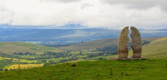
The Yorkshire Wolds Way is a 79 mile National Trail from Hessle on the Humber Estuary to Filey on the North Yorkshire coast. Meandering through rolling chalk hills and peaceful countryside, it offers a tranquil escape in an often-overlooked part of England.

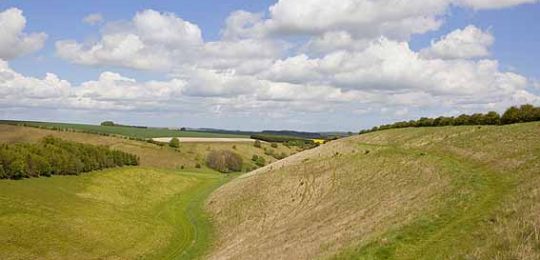
The Yorkshire Wolds offer a peaceful setting for a walking holiday, perfect for those seeking to escape the hustle and bustle. With its rolling countryside and far-reaching views, this 82 mile trail follows well-trodden paths and tracks over higher ground, dipping in and out of the dry valleys carved into the landscape after the Ice Age – features that give the Wolds their unique appearance.
Unlike the rugged drama of some long-distance routes, this is a walk of quiet beauty. A place where time seems to slow, and every step invites you to soak in the landscape’s gentle charm. Starting on the Humber Estuary, the route follows a band of chalk that runs through one of Britain’s most unspoilt rural corners, leading all the way to Filey’s dramatic coastal cliffs. On a clear day, the views stretch for miles across a patchwork of fields, reaching as far as the Pennines and the North York Moors. Keep an eye out for familiar landmarks such as York Minster’s towering spires, and the Humber Bridge, marking the beginning of your journey.
The hedgerows and grassy valleys provide a haven for wildlife, with an abundance of wildflowers, birds, and butterflies flourishing along the trail. In the central section, you may even catch sight of a Red Kite soaring overhead.
The Yorkshire Wolds also have a strong artistic and cultural identity. The WANDER project, ‘Art on the Yorkshire Wolds Way,’ has introduced a series of sculptures and poetry-etched benches along the route, offering moments of reflection and creative inspiration as you walk. Keep an eye out for these unique pieces, seamlessly woven into the landscape.
Ideal for those who enjoy an unhurried pace, the Yorkshire Wolds Way is a journey of quiet discovery, where the beauty lies not just in the views, but in the sense of space, solitude, and the unexpected delights waiting around each gentle corner.
Length
6 - 9 nights
Full Route Length
82 miles / 132 km
Average Grade
Moderate
Why do this walk?
Enjoy gentle trails, good paths, and a relaxed pace through an unspoilt rural landscape.
Experience rolling chalk hills, sweeping views, and the unique dry valleys shaped after the Ice Age.
Marvel at the mighty Humber Bridge, an engineering icon and once the world’s longest single-span bridge.
Spot Red Kites soaring overhead and enjoy the rich wildlife that thrives in the Wolds’ tranquil valleys.
See the landscapes that inspired David Hockney and discover sculptures and poetry along the trail.
Escape the crowds, slow down, and enjoy nature at its most peaceful.
Client Feedback
Read more >Thank you for that great experience. The walks are just AMAZING.
Read more >What made the holiday special, and so easy-going, was the meticulous organisation by Mickledore Travel, from the initial booking to the end of the trip. I know it is a cliché, but Mickledore really did exceed our expectations.
Read more >Your service is awseome. We had the adventure of a lifetime and cant thank you enough! You are the best – Many Thanks!!