Two Moors Way
Wembury to Lynmouth in 12 Days Walking Code: TM13
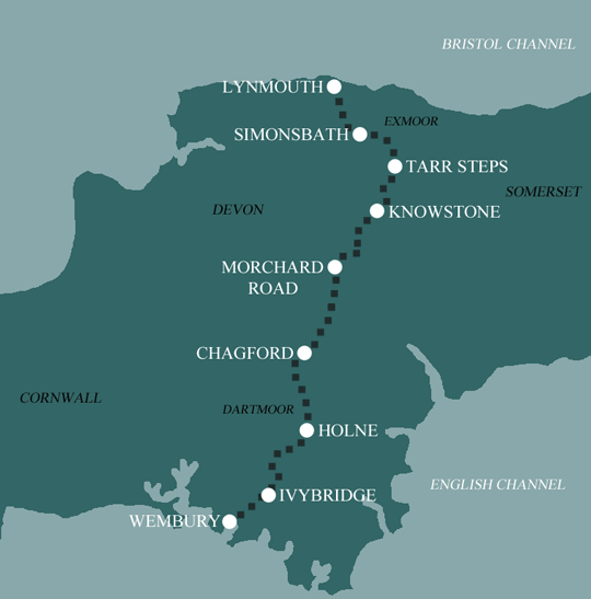
We offer 3 itineraries walking the whole of the Two Moors Way from Wembury on the South Devon coast to Lynmouth on the North Devon coast. Experience wild and windswept Dartmoor, the rural charm of pastoral Mid Devon, and the dramatic landscape of Exmoor all rolled into one magnificent adventure.
This 12 day walk is our longest itinerary and covers the full length of the Two Moors Way at a really comfortable pace for the most part. Unfortunately there is no way of shortening the 14 mile day from Ivybridge to Holne over southern Dartmoor, however 7 of the 12 days never exceed 9 miles.
| Miles | Km | ||
|---|---|---|---|
| Day 1 | Travel to Wembury for your first nights accommodation | ||
| Day 2 | Wembury to Yealmpton | 7 | 11 |
| Day 3 | Yealmpton to Ivybridge then transfer to Yealmpton | 9 | 14 |
| Day 4 | Transfer back to Ivybridge then walk to Holne | 14 | 23 |
| Day 5 | Holne to Widecombe in the Moor | 9 | 14 |
| Day 6 | Widecombe in the Moor to Chagford | 9 | 14 |
| Day 7 | Chagford to Coleford | 13 | 21 |
| Day 8 | Coleford to Morchard Bishop then transfer to Coleford | 7 | 11 |
| Day 9 | Transfer back to Morchard Bishop then walk to Witheridge | 9 | 14 |
| Day 10 | Witheridge to Knowstone then transfer Witheridge | 7 | 11 |
| Day 11 | Transfer back to Knowstone then walk to Tarr Steps | 11 | 18 |
| Day 12 | Tarr Steps to Simonsbath | 11 | 18 |
| Day 13 | Simonsbath to Lynmouth | 11 | 18 |
| Day 14 | Depart from Lynmouth after breakfast |
The original Two Moors Way from Ivybridge to Lynmouth was opened in May 1976. Then in 2005 the Way was officially linked with a section of the Erme-Plym trail from Wembury to Ivybridge to form Devon’s Coast to Coast route. Despite Devon’s Coast to Coast being many years old now, Two Moors Way has remained the favoured name for the full Coast to Coast journey.
Wembury to Ivybridge
It’s never easy leaving the coast, particularly one as stunning as this, but leave the coast you must.
The South Devon section offers a gentle start to this glorious Coast to Coast walk. Starting near the village of Wembury, the route meanders through the rolling fields and delightful wooded valleys of the South Hams. The first two stages, leading to Ivybridge via Yealmpton, are well-marked and easy to follow, utilising good footpaths and bridleways.
Along the way, the path crosses first the Yealm River, followed by the Erme, where it then turns northward through picturesque riverside meadows. As the trail passes near Ermington, known for its crooked church spire, you’ll catch your first glimpse of Dartmoor’s southern slopes, with Western Beacon towering above Ivybridge, offering a preview of the terrain ahead.
Ivybridge to Holne
This is the first official section of the Two Moors Way and one of the most challenging on the entire route. It’s certainly a dramatic shift from the gentle, leafy countryside encountered earlier. Much of this part of the route is unmarked, so if you’re not confident with a map and compass, it’s best in poor weather to follow the low level alternative detailed in your guidebook.
For six miles, the path follows the old Redlake Railway through remote, desolate moorland. The trail then crosses open country, which includes a 19th-century clapper bridge over the River Avon, and passes by Huntingdon Warren, where rabbits were farmed from the mid-13th century until the 1950s. The charming village of Holne offers a welcome respite at the end of this fairly demanding stretch.
Holne to Chagford
A particularly scenic stretch after the bleak moorland of the previous section, but it remains fairly demanding as the route navigates the steep-sided Dart valley with a series of challenging descents and ascents along the way.
The route descends through woodland to cross the River Dart at New Bridge, where an ice cream van often awaits during holidays. The path then follows the elevated Dr Blackall’s Drive, offering stunning views over the Dart Valley, before descending once more to follow the West Webburn River. The route then heads towards the marvellous Hameldown Ridge, leading walkers into the heart of Dartmoor.
Heading for Chagford you have the chance to spot Dartmoor ponies and Highland cattle. The route skirts Grimspound, Dartmoor’s best-preserved Bronze Age settlement, before crossing the trans-moor road near Bennett’s Cross, a 13th-century boundary marker. Hurston Ridge features one of Dartmoor’s longest and best-preserved stone rows. Field paths and woodland tracks lead past ancient farmsteads toward Chagford Bridge.
Chagford to Morchard Road
Aiming for the pretty village of Drewsteignton, this is a gentle stretch, beginning along the peaceful River Teign as it winds towards the stunning Teign Gorge below Castle Drogo, Britain’s ‘youngest’ castle! The trail then climbs to follow the top of the gorge, offering magnificent views. This is a perfect farewell to the Dartmoor segment of the Two Moors Way. A brief detour will take you to the National Trust café at Castle Drogo, but be sure to check opening times before proceeding.
The trail now heads into the quiet, remote landscapes of Mid Devon. A wonderful 30 miles or so of farmland and woodland that lie between Dartmoor and Exmoor. Facilities are admittedly scarce, however on the plus side you will become fully immersed in the untouched Devon countryside, with the opportunity to experience a rich variety of unspoiled flora and fauna. The trail meets with the scenic Tarka Line railway at Morchard Road.
Morchard Road to Knowstone
Beyond Morchard Road is the village of Morchard Bishop and the halfway mark of the original Two Moors Way. This lovely village boasts a good pub, an excellent village shop, and one of the four Two Moors Way marker stones. From here the route continues through tranquil woodland and arable farmlands toward Witheridge. This peaceful stretch passes farmsteads and the pretty hamlet of Washford Pyne, home to St Peter’s Church. Once a bustling coaching town with four pubs and regular fairs and markets, Witheridge is a little quieter now with just a single pub and two shops.
Leaving Witheridge, the trail becomes quieter still as it crosses Bradford Moor, an area of unimproved pasture rich wildlife with wildflowers. The route then follows quiet lanes for several miles toward the two Knowstone moors, Sites of Special Scientific Interest (SSSI), which are now intersected by the North Devon Link Road. The trail passes under this road before reaching the tiny hamlet of Knowstone, where you’ll find a 15th-century church and a pub.
Knowstone to Tarr Steps
Finally, Exmoor is reached, with Peter Randall Page’s sculpture at Badlake Moor Cross facing its twin located 30 miles away near Drewsteignton. As the route ascends Exmoor’s southern slopes, the walk becomes more challenging, but offers rewarding views southward towards Dartmoor. This section is remote, with no facilities along the way.
Although this is the Devon Coast to Coast walk, this stretch of the Two Moors Way crosses into Somerset. From the charming little village of Hawkridge, the trail descends to the famous Tarr Steps, a medieval clapper bridge spanning the River Barle.
Tarr Steps to Simonsbath
For the most part this section follows the scenic River Barle to the 19th-century village of Simonsbath, set in the heart of Exmoor’s former Royal Forest. While the gradients are mostly gentle, the terrain can be more challenging, as the well-trodden riverside path from Tarr Steps to the historic village of Withypool is often wet and muddy, with some uneven patches due to flood damage. At times when the water is particularly high, it may be advisable to divert from the main route for a time and follow the alternative route detailed in your guide book.
Despite the conditions, the walk along the Barle towards Simonsbath is one of the most picturesque sections of the entire route, especially in summer when the area is teeming with wildflowers, butterflies, dragonflies, and damselflies. You may also spot Exmoor ponies grazing on the common above the historic Landacre Bridge, just upriver from Withypool.
Simonsbath to Lynmouth
You’ve reached the final stage of the Two Moors Way … and what a way to finish! Traversing Exmoor’s remotest and wildest country, this is a potentially challenging walk, especially in poor weather. From Simonsbath, the path ascends over rough, boggy terrain towards the source of the River Exe, before crossing the Chains, the highest and most remote part of Exmoor. After navigating more high ground on Cheriton Ridge, the route eases as it follows the Hoar Oak Water.
The final stretch offers stunning views over the dramatic, steep-sided wooded valley of the East Lyn River, with tantalizing glimpses of the coast ahead. A long descent into Lynmouth brings you to a short walk past the harbour, ending at The Esplanade by the Pavilion, and the completion of the Two Moors Way.
Moderate to Challenging
Walking the Two Moors Way brings many rewards. However, it is not without its challenges, especially on the moors and particularly in poor weather. For your safety, and to gain the greatest enjoyment from your walk, it is crucial that you are competent using a map and compass, and that you adhere to the advice in your guidebook.
Seasoned navigators will find the Two Moors Way, even when choosing lengthy days, to be a fairly moderate walk, whereas those less experienced with a map and compass, even with shorter days, will find this a challenging walk.
Terrain: A combination of open moorland, rolling fields, wooded valleys, riverside paths, country lanes, farm tracks and field edges.
What’s it like underfoot? The Erme-Plym extension from Wembury to Ivybridge is along good footpaths and bridleways through rolling fields and woodlands. This is a gentle, unchallenging landscape.
Dartmoor, is a rugged landscape dotted by striking granite tors. Often described as ‘the last wilderness in England’ it is frequently cloaked in mist and lashed by wind and rain. This high rainfall, combined with thin acidic soil, has led to the formation of vast peatlands over the centuries, and the way through is occasionally pathless. Following a dry spell you’ll have a nice springy surface to stride out on.
Mid Devon, between the moors, is a patchwork of small fields, narrow hedged lanes and farm tracks. Much easier going than on the moors.
Exmoor’s moorland plateau is smoother and more rounded in comparison with Dartmoor’s harsh granite. In addition to open common you’ll encounter riverside paths, uneven and wet in places, as well as some rough paths and tracks.
How Much Up & Down? Much of the route is a mix of moderate ups and downs. However, there are some sections, especially as the route crosses open moorland on Dartmoor and Exmoor, that include more demanding ascents and descents.
The highest point of the Two Moors Way is Broad Burrow at Hameldown on Dartmoor, which reaches an elevation of 532 meters (1,745 feet).
Signposting & Naviagtion: The Erme-Plym extension to the Two Moors Way, covering the first 16 miles from Wembury to Ivybridge, is comprehensively waymarked and you should have no problem following the route.
Signage is much less reliable on the moorland sections. Although specific rights of way are clearly marked on maps, navigating on the ground can be more challenging. Don’t expect consistent waymarking on either Dartmoor or Exmoor. While you may find occasional signs where a bridleway crosses common land from a road, the open moor generally lacks any sort of signage. Be sure to follow the directions in your guidebook carefully through these unmarked stretches. If bad weather arises and you're unsure of your navigation skills, you should take the lower level alternatives detailed in your guidebook.
In Mid Devon, the route primarily follows designated rights of way. Some footpath and bridleway signs feature the Two Moors Way symbol, though these vary in age and condition. At other times, you may be following a marked right of way without any indication that it’s part of the Two Moors Way/Devon Coast to Coast route. Fortunately, much of this section is fairly user friendly, and field edges often have a clear, uncultivated strip accommodating walkers.
Ultimately, when walking the Two Moors Way it is crucial that you are competent with a map and compass, and you adhere to the advice in your guidebook, including using lower level alternatives in poor weather.
Weather: The southwest benefits from a relatively mild climate with Devon experiencing some of the highest average year-round temperatures in the country. However, Devon's position leaves it exposed to frequent Atlantic weather systems, driven by prevailing south-westerly winds, which bring heavy rain to the coasts and moorlands. Fingers crossed you will experience warm, dry weather throughout your holiday and enjoy dry paths and tremendous views, but you must be prepared because the weather can change quickly, especially on moorland and over high ground. Good clothing, comfortable footwear and reliable waterproofs are essential. It is important you carry plenty of water on warm days. Pack your floppy hat and sun cream also!
|
All Holidays
|
|
| Accommodation | Overnight Bed and Breakfast accommodation in selected hotels, farmhouses, village inns, guest houses and family B&Bs. Cooked or Continental breakfast. |
| Guidebook | A detailed guidebook with route information, maps, photos and background information. |
| Information of Services Along the Route | A comprehensive Service Info sheet, including services such as cash points, banks, post offices, village shops, inns, cafes and taxis. |
| Maps | Four (1:50,000) Ordnance Survey Landranger maps, including mobile download, covering the Two Moors Way route. |
| Personal Itinerary | A personal itinerary setting out each overnight stop, including large scale maps of each accommodation, to ensure you find it easily. |
| Emergency Telephone Support | If you get in to difficulties during your holiday, we are always available to help, even out of office hours. |
|
Options
|
|
| Luggage Transport | We will transfer your luggage between each overnight stop – if you leave your luggage at the accommodation when you set off in the morning, it will be moved on to your next B&B. You only need to carry a small day sack with the clothes and provisions you require during the day’s walk. |
| Packed Lunches |
Provided for each day’s walking, where offered by your host, and recommended on this holiday. In the absence of pre booked packed lunches, or making arrangements with your host on arrival, it is important you purchase enough food and drink for the day before setting off, as it is highly unlikely there will be refreshment stops along the route. |
| Off Road Parking | If you are travelling by car we can usually arrange off road parking for the duration of your trip. (There may be a small charge for this). |
| Arrangement of return transport | We can also arrange your transfer back to your car, (or advise you when public transport is a better option)! |
|
What’s not Included
|
|
| Evening Meals | Your evening meal isn’t included in the package, but we include full details and recommendations for each evening in your itinerary. You will be within walking distance of a pub and/or restaurant each evening. Allow about £30.00 per night. |
| Transport to the Start & Away from the Finish | Have a look at the ‘Travel Info’ tab above for suggestions. If you’re still struggling, get in touch and we’ll help you sort it out. |
| Travel Insurance | Even if you are based in the UK travel insurance is worth having. |
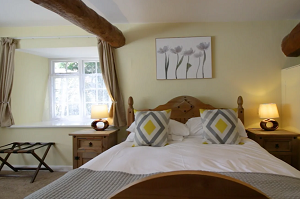
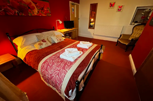
Good accommodation and friendly hosts are an essential part of any holiday. We understand this and go out of our way to find the best. We put a great deal of effort into hand picking our accommodation and matching it to individual customer requirements. As well as visiting the accommodation ourselves, we ask all our customers to complete a short evaluation on each night’s accommodation, which then gives us an insight into the day-to-day operation and lets us spot any potential issues before they become a problem.
We use a variety of accommodation on the Two Moors Way including family run bed and breakfast, village inns and small characterful country hotels. Rooms on the Two Moors Way are a variety of ensuite, private and shared facilities, and it is possible you will experience a mix of each on your holiday.
We are happy to book single rooms on our holidays but cannot normally book more than two for any one group. Single room bookings include a supplement.
Here are some examples of the accommodation we use on the Two Moors Way:
 Nestled in the picturesque village of Yealmpton in Devon’s South Hams, the Rose & Crown is a stylish and inviting pub known for its outstanding cuisine, award-winning ales, and comfortable accommodation. Enjoy a cosy atmosphere, complete with snug corners, plush sofas, and a crackling fireplace. Visit their website
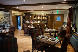
 The New Inn at Coleford, with its traditional beams and flagstone floors, is a hidden treasure for those seeking refreshment or a place to rest. This charming Devon country inn is renowned for its selection of Devon ales, its restaurant, serving some of the finest local cuisine, and of course its warm hospitality. Visit their website
 The Mitre Inn, a charming 17th-century pub in Witheridge, offers cosy bed and breakfast accommodation in the heart of the Devon countryside. Ideal for walkers on the Two Moors Way or those exploring nearby Tiverton, it features traditional decor, an open fire, and delicious food in a welcoming setting. Visit their website
 Tarr Farm Inn is a charming 17th-century inn nestled in the heart of Exmoor National Park, right beside the historic Tarr Steps on the River Barle. Renowned for its award-winning cuisine, the inn offers a cosy bar where you can enjoy a hearty menu, as well as a more formal restaurant featuring an à la carte selection. Visit their website
General travel information for the Two Moors Way will be in your holiday pack.
Detailed instructions on getting to your first night’s accommodation by car, or on foot from the nearest train or bus station, will also be included in the holiday pack on individual accommodation maps.
To view train times please visit trainline where you can also purchase tickets in advance. For information on bus timetables please visit traveline
Getting to Wembury:
By Air: The nearest International Airports to the trail are Bristol and London Heathrow. There are also airports at Exeter and Newquay which are convenient for direct flights from Europe and connecting flights from various UK airports.
By Public Transport: There is a railway station at Plymouth. Plymouth Railway Station (PLY) is located on the Cornish Mainline from where there are onward services throughout Cornwall and further afield to London (Paddington), Birmingham, Leeds and Edinburgh. It is also the western terminus of the Exeter-Plymouth branch line. Buses run regularly from Plymouth to Wembury.
By Road: Wembury is reached from the Marsh Mills roundabout on the outskirts of Plymouth. Leave the M5 motorway just after Exeter at Junction 31 and follow signs for A38 Plymouth.
Returning from Lynmouth:
By Public Transport: The nearest mainline railway station to Lynmouth is Barnstaple. Barnstaple station (BNP) is located is on the Tarka Line, which connects to Exeter St David’s, which in turn links to the broader UK rail network including London (Paddington), Birmingham, Leeds and Edinburgh. Buses run regularly from Lynmouth to Barnstaple.
By Road: The A39 runs directly through Lynmouth. Leave the M5 motorway at Junction 23 (Bridgewater) and follow signs for the A38 Bridgewater and then the A39 Lynmouth.
Lynmouth
Spend a day exploring the picturesque twin villages of Lynton and Lynmouth, dubbed “England’s Little Switzerland” ever since Robert Southey remarked upon their distinctly Alpine appearance. Ride the Cliff Railway funicular which connects Lynmouth at the foot of the cliffs to Lynton, perched 500 feet above. Visit Watersmeet and indulge in a cream tea (and argue about where the jam goes) in the tea garden before exploring the ancient woodlands in and around one of the country’s deepest river gorges. There are plenty of historic houses and gardens nearby, or just spend a day experiencing the local arts and crafts and a spot of shopping.
| Prices | GBP (£) |
|---|---|
| Accommodation, map & guidebook only | £1479 |
| with Luggage Transport | £1695 |
| with Packed Lunches | £1617 |
| with Luggage & Lunches | £1822 |
Other Options |
|
| Extra Nights (per night) | £95 |
| Single Supplement (per night) | £65 |
| Solo Luggage Supplement (per day) | £18 |
